

During one and the same nationally declared heat wave, Cordoba can pass 44 degrees Celsius (111°F) while a coastal city stays below 35 (95°F). Both sit under the same mass of hot air, but they experience it completely differently, and the reason has nothing to do with the intensity of the weather system and everything to do with the geography of each area.
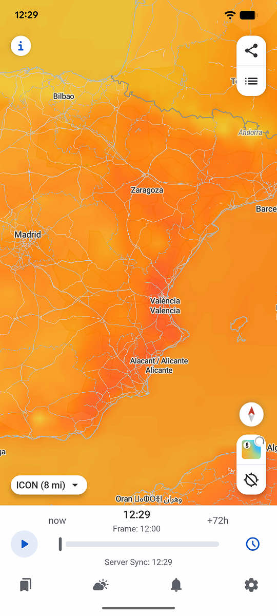
The interior heats up more because the sea is not nearby
Water takes far longer than land to warm up and to cool down. That simple physical difference explains much of the thermal contrast within Spain during a heat wave. Inland areas, such as the Guadalquivir valley or the central plateau, have no nearby body of water to moderate the temperature, so the air warms far more directly and reaches higher peaks.
The Guadalquivir valley, including Cordoba and Seville, routinely records some of the highest maximum temperatures in Europe during a heat wave, because of its inland position ringed by high ground that restricts ventilation.
The shape of the terrain makes matters worse in some areas. The Guadalquivir valley is partly surrounded by mountain ranges, which limits the arrival of cooler air and lets heat accumulate over several consecutive days with hardly any air renewal.
The coast gets less heat but more humidity
In coastal areas, the Mediterranean moderates the maximum temperature but introduces another factor: humidity. Air loaded with water vapour coming off the sea makes the heat feel more intense than the thermometer suggests, even when the absolute temperature is several degrees lower than inland. A temperature of 33 degrees Celsius (91°F) with high humidity on the coast can feel as exhausting as 40 degrees (104°F) of dry inland heat.
That difference explains why heat-wave warnings in Spain are almost never uniform across the country. AEMET, the national weather agency, issues separate warnings by province, and sometimes even by district, precisely because the same mass of hot air produces very different impacts depending on the local geography.
The extra role cities play inside each region
Inside any region, whether inland or coastal, large cities usually record higher temperatures than the countryside around them, because of the urban heat island effect. Asphalt and concrete hold the heat absorbed during the day and release it slowly at night, which keeps the temperature from falling far enough even after sunset. An inland city not only starts from a hotter climatic baseline, it adds this urban effect on top, which can turn an already intense regional heat wave into something still more extreme within the urban core itself.
That double effect, regional geography plus urban environment, is why cities in the Guadalquivir valley appear so consistently among the places with the highest temperatures recorded in Europe during heat-wave episodes.
Why comparing maximum temperatures alone is not enough
Looking only at the national maximum during a heat wave can lead to the wrong conclusion about which area is actually suffering most. A coastal city at 34 degrees Celsius (93°F) with high humidity can represent more real health risk than an inland city at 42 (108°F) of dry heat, depending on how the apparent temperature is calculated.
RainViewer lets you save several locations and compare their temperature and forecast side by side, showing how the same heat wave affects each area differently.
Compare areas, not just the national headline
A heat wave declared for the whole of Spain hides important regional differences that a national headline cannot capture. Knowing whether one specific area is among the worst affected or among the relatively milder ones requires comparing several locations directly, rather than relying on a single national figure.
RainViewer lets you save several locations and compare their temperature and forecast side by side, useful both for people who live in different parts of the country and for anyone deciding where to travel during a heat wave.



 RainViewer
