

A yellow-code weather warning for thunderstorms with lightning shows up on phones across Romania all summer, but few people know exactly which criterion triggers that message, or what really separates it from an orange or red code for the same kind of weather.
Romania’s ANM system, in four colours
The National Meteorological Administration uses a system of four colour codes: green, yellow, orange and red, in increasing order of severity. Each code corresponds to specific intensity thresholds for the forecast phenomenon, as well as to a particular geographic area covered by the warning.
A yellow code for thunderstorms with lightning signals intense but usually localised weather that calls for extra attention rather than emergency measures.
Yellow is the most common of the three active levels, because the threshold that triggers it is relatively easy to reach during the warm season, when atmospheric instability produces storms frequently.
What “moderate” actually means
The word “moderate” in the name of the warning does not describe a weak storm. It describes where the warning sits in the official hierarchy of codes. A warning for moderate phenomena can still include frequent lightning, wind gusts and heavy short-duration rainfall, enough to disrupt outdoor activity or road traffic, even when it does not reach the threshold for an orange or red code.
The real difference between codes is not only intensity, it is institutional response. A yellow code generally means continuous monitoring without special measures. Orange or red can mean local intervention plans are activated, depending on the severity forecast.
Why codes differ between one hazard and another
A less well-known aspect of the ANM system is that the same weather event can generate different codes for different phenomena on the same day. A storm might receive an orange code for lightning while, for the same area and the same period, the wind code stays yellow, because the forecast wind does not reach the threshold for a higher level. Each type of phenomenon, rain, wind, lightning, hail, is assessed separately, even when all of them come from the same atmospheric system.
That separation by hazard type explains why a bulletin can look contradictory at first glance, with several different codes for the same area on the same day. It is not an inconsistency in the system, but a reflection of the fact that a single storm can produce risks of very different intensity for each type of phenomenon.
Why the area covered matters as much as the code
A warning issued for an entire county does not mean the weather will affect that whole territory evenly. Thunderstorms with lightning are localised by nature, forming and dissipating within a few hours and affecting a limited area while the rest of the county stays completely untouched.
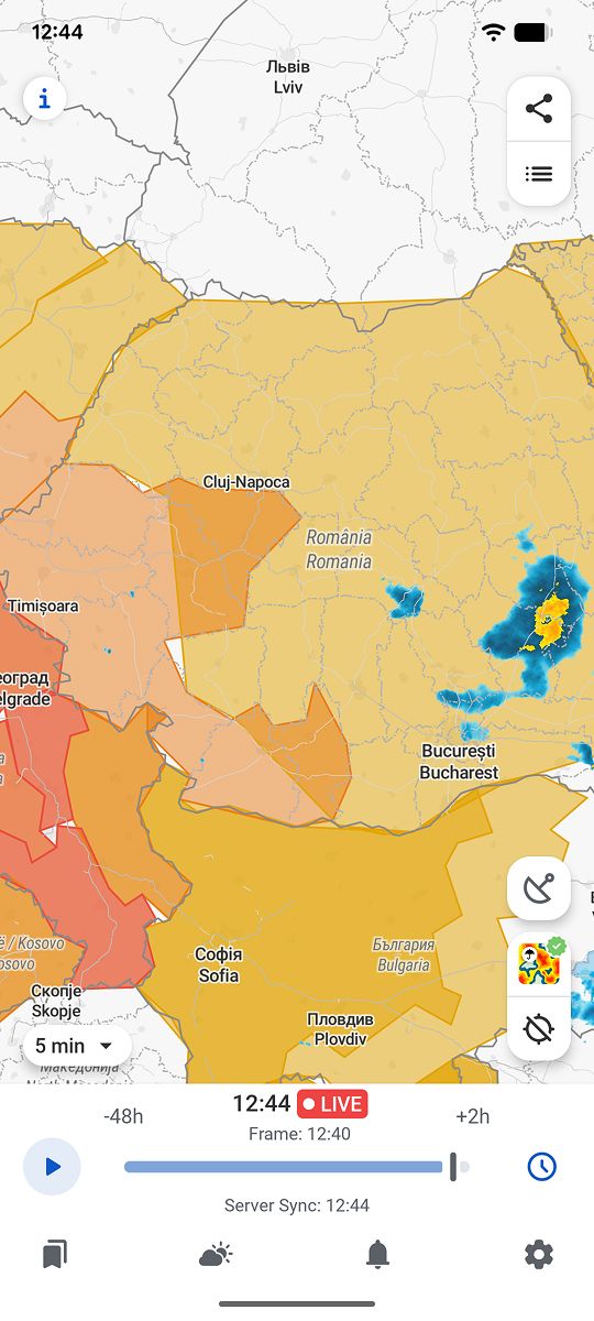
RainViewer shows official ANM weather warnings directly on the radar map, with the exact area covered relative to a saved location, not just the name of the county in the alert.
See the exact area, not just the colour code
An official warning gives a useful general frame, but it does not answer the most practical question: whether a particular location is genuinely inside the affected area at that moment. That takes seeing the warning itself on the map, next to live radar.
RainViewer shows official ANM weather warnings directly on the radar map, so you can see exactly which area is covered relative to a saved location.



 RainViewer
