

Anyone who has lived in Thailand long enough knows the pattern. A bright morning, a heavy, humid midday, and then between two and four in the afternoon the clear sky darkens fast, heavy rain falls for half an hour to an hour, and it stops in time for the evening. That pattern is not luck. It is the result of a physical mechanism that repeats almost every day of the wet season.
The heat that builds all morning is the starting point
It all starts with the sun. From early morning, the ground and buildings absorb heat, and the air sitting on top of them warms with it. Warm air is lighter than cool air, so it rises. The further past midday, the more warm air is rising. That process is called convection, and it drives the kind of rain known as convective rain, which is different from the frontal rain of temperate zones.
When warm, humid air rises high enough, it cools and condenses into cumulus clouds. If there is enough moisture in the air and the energy keeps feeding upward, small clouds develop into cumulonimbus, the thunderstorm cloud, which can stand several kilometres tall. The whole process, from the first accumulated heat to a fully built storm cloud, typically takes four to six hours, which is exactly the span from morning to mid-afternoon.
Convection from the first morning heating to a fully developed thunderstorm cloud takes roughly four to six hours, which explains why the rain usually falls in the afternoon.
Why the rain stops about as fast as it starts
Convective rain is short-lived compared with other kinds, because the energy driving it comes from heat accumulated during the day. Once the rain starts falling, cool air flows down from above and replaces the warm air that had been rising, which cuts off that storm’s own energy source. The cloud dissipates quickly, and once the sun drops lower in the late afternoon there is no new heat to feed the cycle, so this kind of rain usually ends before dusk.
The short burst of intensity comes from the same mechanism. A cumulonimbus can drop very heavy rain over a narrow area within a few tens of minutes, because all the energy stored over half a day is released at once in a short window. That is why afternoon rain in Thailand tends to be heavy but brief, unlike monsoon rain that can fall steadily all day.
Why some days stay dry even in extreme heat
Convection needs more than heat. If the air aloft is too dry, or a warm layer sits between the ground and the level where clouds should form, the warm air rising from the surface can stall halfway and never develop into a thunderstorm cloud. That is why some days stay hot and heavy all day without a drop of rain: there is enough heat, but not enough moisture or the right atmospheric structure for the cloud to keep growing.
The reverse is true too. A day that does not feel especially hot but carries very high humidity can still produce violent thunderstorms, because moisture is fuel just as much as heat is. Both have to arrive in the right proportion. Convective rain does not depend on temperature alone, as many people assume.
The same pattern every day does not make it easy to predict
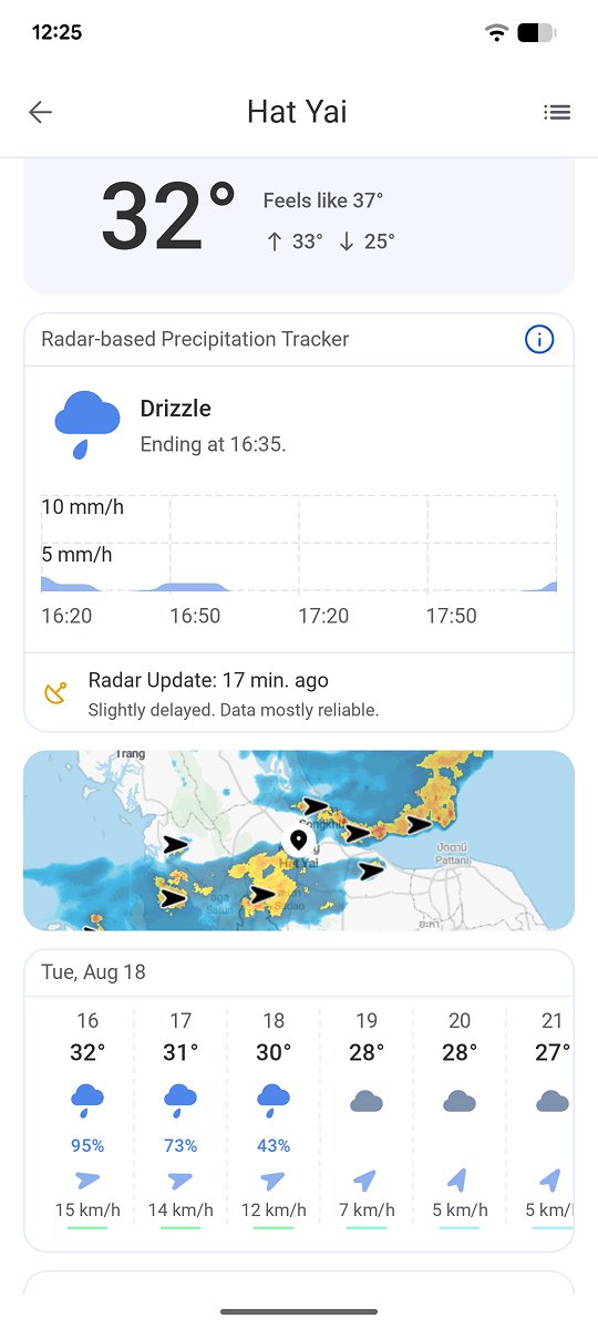
The overall mechanism repeats daily through the wet season, but the spot where the heaviest rain falls does not repeat with it. Storm clouds form according to very local factors: soil moisture, light wind direction, and heat accumulated in one specific area. So on some days one side of a city takes heavy rain while the other stays completely dry. Knowing that rain usually falls in the afternoon is useful general knowledge, but knowing where it will fall in the next twenty minutes takes real-time tracking of the cells themselves.
RainViewer updates radar data every 5 to 10 minutes, so you can see afternoon storm cells building nearby before the rain reaches the ground.
Know before the rain arrives
A rain pattern that repeats every afternoon is an advantage for anyone planning to go out, because the high-risk window is already known. What it does not give is the exact position of the rain in real time, which is what tells you where the rain is about to fall, not just when.
RainViewer shows where thunderstorm cells are building in real time, so you can see them before the rain reaches the ground in your area.


 RainViewer
