Peta Penjejakan Taufan
Ribut tropika adalah kawasan tekanan rendah yang sangat rendah di permukaan bumi. Ribut tropika dengan kelajuan angin lebih daripada 73 mph termasuk dalam kategori taufan. Taufan yang kuat dari kategori 2 dan ke atas boleh menyebabkan bencana alam dan kerosakan. Oleh itu, pengiktirafan mereka sebelumnya dan menjaga situasi di bawah kawalan adalah penting. Peta langsung fenomena semula jadi ini akan membantu mengesan zon pengungsian taufan, memperingatkan tentang bencana seperti banjir, dan menyumbang kepada keselamatan awam.
Taufan Aktif
Kemas kini terakhir:
| Nama | Kategori | Kelajuan angin | Bergerak |
|---|---|---|---|
| Taufan Kategori 2 | 148 kmj | B 18 kmj | |
| Taufan Kategori 4 | 148 kmj | BL 31 kmj | |
| Taufan | 120 kmj | BL 17 kmj |
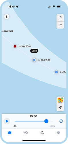
Halaman radar taufan kami membolehkan anda menjejaki pergerakan taufan dan ribut tropika di peta. Untuk mengetahui di mana ribut sebenar sedang bergerak, klik ikon di sudut kanan atas peta. Anda akan melihat rantai titik berwarna-warni yang membentuk laluan lalu, semasa, dan jangkaan taufan, siklon, atau ribut tropika. Ramalan kawasan pergerakan meramalkan zon di mana siklon boleh pergi dengan laluan paling mungkin di tengah zon tersebut.
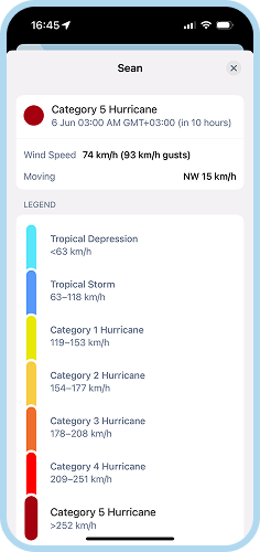
Jenis-jenis ribut tropika yang berbeza ditandai dengan warna yang berbeza di peta:
- Depresi Tropika (<38 mph)
- Ribut Tropika (39-73 mph)
- Taufan Kategori 1 (74-95 mph)
- Taufan Kategori 2 (96-110 mph)
- Taufan Kategori 3 (111-129 mph)
- Taufan Kategori 4 (130-156 mph)
- Taufan Kategori 5 (157 mph atau lebih tinggi)
Lebih dalam aplikasi
Dalam aplikasi RainViewer, anda boleh meneroka lebih mendalam tentang ribut tropika akan datang, dari pembentukan awal hingga mendarat dan seterusnya.
Maklumat ribut lanjutan
Anda boleh ketik setiap titik laluan ribut tropika dan melihat butiran tentangnya, seperti kategori, kelajuan angin (termasuk pasang surut ribut yang mungkin), dan kelajuan pergerakan.
Pemberitahuan ditekan
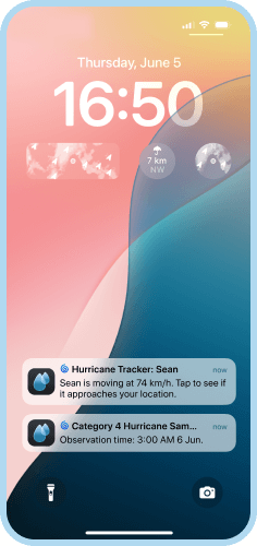
Kami menghantar pemberitahuan tepat pada masanya melalui aplikasi jika ribut taufan berada berdekatan dengan bandar atau kawasan anda. Ini memberi anda masa yang mencukupi untuk mengungsikan diri dan mendapatkan bantuan lanjutan, jika perlu.
Tetapan pantas
Anda boleh dengan cepat menghidupkan dan mematikan jejak ribut di tetapan pantas terus di peta, bersama dengan banyak lapisan lain, seperti data satelit, liputan radar, zon cuaca buruk, dll.


Bolehkah radar cuaca mengesan ribut taufan?
Apabila taufan berada dalam lingkungan kira-kira 325 km atau 200 batu dari pantai, radar cuaca berasaskan darat boleh mengesannya. Radar seperti ini memberikan data terkini tentang intensiti hujan, pergerakan ribut tropika, dan kelajuan. Akibatnya, Perkhidmatan Cuaca Nasional boleh mengeluarkan amaran jangka pendek untuk angin kuat, puting beliung, dan banjir di kawasan tertentu. Penilik Hujan mempunyai akses kepada data dari lebih 1000 radar di seluruh dunia. Oleh itu, kami boleh menyediakan maklumat paling terkini tentang siklon dan taufan semasa, yang dikemas kini dalam masa nyata.
Bagaimana untuk menjejaki ribut taufan di peta?
Untuk menjejak taufan pada peta kami, anda harus menghidupkan jejak ribut tropika. Untuk melakukannya, klik ikon di sudut kanan atas. Ini akan memaparkan rantai titik yang ditandai dengan warna yang berbeza yang mewakili skala ribut tropika. Nama taufan semasa menunjuk pada titik yang ditandai dengan warna yang sepadan dengan jenisnya sekarang. Dalam aplikasi Penilik Hujan, anda boleh mengetik nama taufan untuk mendapatkan maklumat lanjut mengenainya.