Cyclone Tracker Zambia
The Storm Tracks layer shows current position, past path, forecast path, and the cone of probable tracks.


RainViewer shows storm tracks on one map for Zambia and the Zambezi River.
The Storm Tracks layer shows current position, past path, forecast path, and the cone of probable tracks.
Current cyclones near Zambia
Zambia is a landlocked country in southern Africa, and the Zambezi River forms much of its southern border. This list names each active tropical storm or cyclone near Zambia, with its category and status. Each storm links to its own tracker page.
No active tropical storm or cyclone is listed near Zambia.
Last updated:
How RainViewer shows storms
The Zambia Meteorological Department publishes the official weather warnings and storm information for Zambia. The Storm Tracks layer on the RainViewer map shows current position, past path, forecast path, and the cone of probable tracks. RainViewer does not replace official warnings.
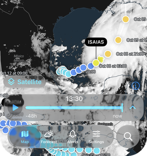
See the full storm path
Tap any point on the path to see wind speed, category, and direction at that point.
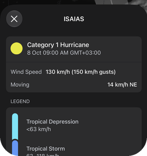
Read the category in one place
Open any storm to see its category and intensity.
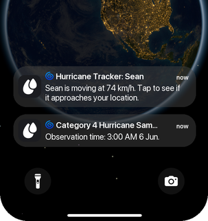
Get a notification when a storm approaches
RainViewer sends a Tropical Storm Alert when a storm approaches your area.


See Zambia storms in RainViewer
When is cyclone season in Zambia?
Cyclone season in Zambia follows the south-west Indian Ocean season and runs from about mid-November to late April, according to Météo-France La Réunion.
A cyclone starts as a cluster of thunderstorms over warm ocean water. Warm, moist air rises from the sea surface. The air pressure near the surface drops, and more air flows in. The rotation of the Earth makes this air spin, clockwise in the Southern Hemisphere. Weak winds high in the atmosphere let the system organize. A system with a closed circulation is called a tropical depression. It becomes a tropical storm when its winds strengthen, and a regional warning centre gives it a name. It becomes a cyclone when its winds reach cyclone strength.
Sea temperatures in the Mozambique Channel are highest in the southern summer. This is the time of the most storm activity. Cyclones often form over the warm water of the Indian Ocean east of Madagascar and in the Mozambique Channel. Zambia has no coast. Cyclones that cross Mozambique can bring heavy rain to the country as weaker systems. The Zambezi River flows on toward Mozambique and the Indian Ocean.
Storms in nearby regions
Looking for storms near Zambia? See the cyclone trackers for Malawi, Zimbabwe, Mozambique, or open the tracker for all regions.
Cyclone Strength, From Depression To Super Cyclone
Depression (31–49 km/h)
A low-pressure area with organized rain. No name yet.
Deep Depression (50–61 km/h)
Heavy rain over a wide area, rough seas.
Cyclonic Storm (62–88 km/h)
The storm gets a name. Downed branches, flooding in low areas.
Severe Cyclonic Storm (89–117 km/h)
Damage to thatched roofs and power lines, coastal flooding.
Very Severe Cyclonic Storm (118–166 km/h)
Roof damage to buildings, uprooted trees, storm surge on exposed coasts.
Extremely Severe Cyclonic Storm (167–221 km/h)
Serious structural damage, communication and power lines down over a wide area.
Super Cyclonic Storm (222 km/h or higher)
Widespread destruction and major storm surge along the coast.
FAQ
Where can I see current cyclones near Zambia?
The cyclone tracker map on this RainViewer page shows current storm tracks near Zambia, and the list under the map names each active storm near Zambia. When no storm is active, the list says so and links to storms in other regions. Past storms near Zambia are listed further down the page.
When is cyclone season in Zambia, and which months are busiest?
Cyclone season in Zambia runs from about mid-November to late April, according to Météo-France La Réunion, the regional warning centre for the south-west Indian Ocean. The busiest months fall inside this period. Zambia has no coast. Cyclones that cross Mozambique can bring heavy rain to the country as weaker systems. The Zambezi River flows on toward Mozambique and the Indian Ocean.
Which official source issues cyclone warnings for Zambia?
The Zambia Meteorological Department publishes the official weather warnings for Zambia, and Météo-France La Réunion publishes forecasts and advisories for every active storm in the south-west Indian Ocean basin. RainViewer shows storm tracks on a map and does not replace official warnings. Météo-France is the source for official basin forecasts.
What does the forecast cone show on the Zambia map?
The forecast cone on the RainViewer map shows the probable track of the center of a storm during the forecast period. The cone does not show how far wind, rain, or storm surge reach from the center, so areas outside the cone can still have storm effects. The cone is part of the Storm Tracks layer, together with the current position, the past path, and the forecast path.
Where can I see rain radar for Zambia?
RainViewer shows rain radar for Zambia, and the Zambia weather radar page lists radar coverage and links to city radar pages. RainViewer updates radar every 5 minutes. Radar shows rain inside a storm. The Storm Tracks layer shows where the storm is moving.
 RainViewer

