Карта опадів онлайн
Відстежуйте опади за допомогою онлайн-карти радарів Rain Viewer, яка оновлюється кожні 10 хвилин через NOAA, EUMETNET та понад 1000 світових радарів. Контролюйте дощ, сніг та шторми у реальному часі по всьому світу.
Переглядайте опади у реальному часі з понад 1000 радарів. Відкрийте доступ до розширених інструментів та сповіщень разом із додатком Rain Viewer.
Відкрийте новий рівень прогнозу погоди з додатком Rain Viewer
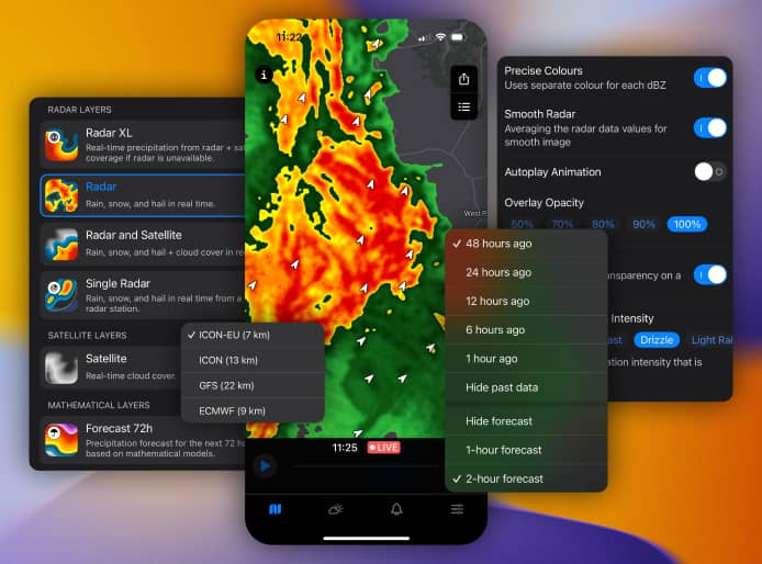
Ця карта живого радaра лише попередній перегляд. Додаток Rain Viewer забезпечує неймовірну швидкість, точність і налаштування:
- Миттєві сповіщення: отримуйте попередження про дощ, сніг чи небезпечні погодні явища — прямо на ваш телефон.
- Плануйте розумніше: використовуйте точні, гіперлокальні прогнози, щоб впевнено організовувати заходи на вулиці.
- Відстежуйте шторми як професіонал: аналізуйте рух бурі за допомогою розширених радарних інструментів — ідеально для метеоентузіастів і "мисливців за штормами".
- Блискавична робота: карти завантажуються менш ніж за 3 секунди, щоб ви завжди були в курсі без затримок.
Відгуки наших користувачів
-

«Іноді трохи неточно передбачає дощ, але це всерівно точніше конкурентів і коштує своїх грошей, і це єдиний погодний додаток, який я зберіг і не видаляв»
 Duncan Stewart
 -
«Я мушу ще раз змінити свій відгук. Це все ще найкраща програма для погоди у магазині додатків. Проблема у мене була з моїм телефоном, а не з цією найкращою програмою, але мені дуже подобаються віджети»
 Джим Тігс
Глобальне покриття, якому можна довіряти
Rain Viewer підключається до понад 1000 радарів по всьому світу, щоб надати всебічні та надійні дані:
- Точність у США: детальне покриття від Сіетла до Флориди через мережу NOAA.
- Світове охоплення: відстежуйте шторми від Бразилії до Японії за допомогою EUMETNET та локальних джерел.
Оглянути покриття радарів
Є питання? Маємо відповіді
Питання: Що показує карта живого погодного радара?
Відповідь: Карта живого погодного радара показує у реальному часі дощ, сніг чи град, оновлення кожні 10 хвилин. Дані Доплера відображають інтенсивність та рух бурі, щоб ви були попереду.
Питання: Навіщо встановлювати Rain Viewer?
Відповідь: Це ваш набір радарних інструментів — швидші карти, шари швидкості, однорадарні дані. Створено для тих, хто аналізує бурі, а не лише прогноз погоди.
Питання: Чи додаток безкоштовний?
Відповідь: Так, завантаження та використання безкоштовне. Преміум відкриває мапи без реклами, додаткові шари та багато іншого за секунди.
Питання: Наскільки точний радар?
Відповідь: Ми використовуємо дані від NOAA i понад 1000 глобальних радарів, оновлення кожні 5 хвилин для максимальної точності. Точність радара — від 250 метрів до 1 кілометра, залежно від відстані радара до цілі й атмосферних умов. Чим ближче радар, тим вища роздільна здатність. На точність також впливають інтенсивність дощу, рельєф та висота радіолокаційного променя.
Завантажте зараз — будьте на крок попереду погоди
Отримайте потужність професійного радара у вашій кишені. Завантажте Rain Viewer безкоштовно і більше ніколи не потрапляйте під дощ зненацька.

