Weather Radar Map Live
Track precipitation with RainViewer's live radar map, updated every 10 minutes via NOAA, EUMETNET, and 1000+ global radar sources. Monitor rain, snow, and storms in real-time worldwide.
- App Only
Track up to 20 locations
Home, office, kids' school - all at once, no switching tabs.
- App Only
Alerts for each of them
Get notified 15 minutes before rain - while you can still change your plans.
- App Only
Widgets on your home screen
Live radar without opening the app - on your lock screen or home screen.
Free to download * Essential from $0.83 * Prices vary by region and promotions.
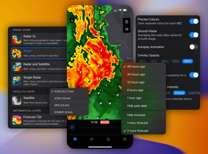
Unlock Next-Level Weather with the RainViewer App
This live radar map is just a preview. The RainViewer app delivers unmatched speed, accuracy, and customization:
- Instant Notifications: Stay ahead with alerts for rain, snow, or severe weather - delivered straight to your phone.
- Plan Smarter: Use accurate, hyper-local forecasts to schedule outdoor activities with confidence.
- Track Storms Like a Pro: Analyze storm movement with advanced radar tools - ideal for weather enthusiasts and storm chasers.
- Lightning-Fast Performance: Maps load in under 3 seconds, keeping you in the know without delay.
What Our Users Say

“A little enthusiastic sometimes with rain predictions but it's accurate and in the money for radar images, and the one radar app I've kept and not uninstalled”
 Duncan Stewart
“I must change my feedback once more this is still the best brain app in the app store the issue I was having was with my phone and not this top of the line app one part I really like is the widgets.”
 Jim Tigs
Global Coverage You Can Trust
RainViewer taps into over 1000 radars worldwide for comprehensive, reliable data:
- U.S. Precision: Detailed coverage from Seattle to Florida via NOAA's network.
- Worldwide Reach: Track storms from Brazil to Japan with EUMETNET and local sources.
Explore Radar Coverage
Thailand
- Bangkok
- Chon Buri
- Chiang Mai
- Surat Thani
- Nakhon Ratchasima
- Phuket
- Nakhon Sawan
- Prachuap Khiri Khan
- Khon Kaen
- Kanchanaburi
- Saraburi
- Nonthaburi
- Chachoengsao
- Samut Prakan
- Songkhla
- Phitsanulok
- Ubon Ratchathani
- Pathum Thani
- Ang Thong
- Pattani
- Narathiwat
- Phra Nakhon Si Ayutthaya
- Trang
- Rayong
- Uttaradit
- Nakhon Si Thammarat
- Samut Sakhon
- Krabi
- Nakhon Pathom
- Satun
- Loei
- Kamphaeng Phet
- Udon Thani
- Chiang Rai
- Suphan Buri
- Sakon Nakhon
- Lampang
- Phetchabun
- Prachin Buri
- Phang Nga
- Lopburi
- Chumphon
- Phichit
- Ratchaburi
- Si Sa Ket
- Sukhothai
- Roi Et
- Buri Ram
- Lamphun
- Phetchaburi
- Tak
- Surin
- Chanthaburi
- Phayao
- Phrae
- Kalasin
- Chaiyaphum
- Maha Sarakham
- Trat
- Nakhon Nayok
- Nakhon Phanom
- Uthai Thani
- Nong Khai
- Nan
- Chai Nat
- Yasothon
- Yala
- Bueng Kan
- Mae Hong Son
- Mukdahan
- Ranong
- Samut Songkhram
- Nong Bua Lam Phu
- Sing Buri
- Amnat Charoen
Germany
- Frankfurt am Main
- Berlin
- Munich
- Hamburg
- Cologne
- Dusseldorf
- Dortmund
- Stuttgart
- Leipzig
- Nuremberg
- Hanover
- Bamberg
- Mannheim
- Essen
- Heidelberg
- Friedrichshafen
- Bonn
- Giessen
- Dresden
- Munster
- Ingelheim am Rhein
- Augsburg
- Braunschweig
- Halle (Saale)
- Stadthagen
- Bispingen
- Bielefeld
- Bremen
- Duisburg
- Aachen
- Ludenscheid
- Gelsenkirchen
- Cloppenburg
- Kaufbeuren
- Kassel
- Norderstedt
- Goslar
- Wiesbaden
- Koblenz
- Kitzingen
- Itzehoe
- Rosenheim
- Monchengladbach
- Grimma
- Schwerin
- Ludwigsburg
- Bad Oeynhausen
- Hamm
- Schwabach
- Saalfeld
- Wolgast
- Brandenburg
- Magdeburg
- Karlsruhe
- Luneburg
- Rheine
- Bad Mergentheim
- Bad Kreuznach
- Frankenberg (Eder)
- Gorlitz
- Kiel
- Darmstadt
- Freiburg im Breisgau
- Beverungen
- Krefeld
- Eisenach
- Jena
- Meppen
- Hildesheim
- Salzgitter
- Bochum
- Paderborn
- Saarbrucken
- Eschweiler
- Achim
- Wurzburg
- Sinsheim
- Sonnewalde
- Wuppertal
- Bad Neustadt an der Saale
- Chemnitz
- Euskirchen
- Sylt
- Crailsheim
- Freiberg
- Luckenwalde
- Oldenburg
- Melle
- Greifswald
- Kirchheimbolanden
- Winterberg
- Erkner
- Wurzen
- Cham
- Erfurt
- Limburg
- Dachau
- Siegen
- Alzey
- Linden
- Hoyerswerda
- Regensburg
- Flensburg
- Erlangen
- Floha
- Lubeck
- Rahden
- Laage
- Solingen
- Heilbronn
- Soltau
- Dreieich
- Potsdam
- Pritzwalk
- Celle
- Landsberg am Lech
- Osnabruck
- Furth
- Mechernich
- Bayreuth
- Mainz
- Ilmenau
- Wolfsburg
- Greiz
- Bassum
- Stendal
- Zwickau
- Cottbus
- Varel
- Velbert
- Trier
- Aschaffenburg
- Oberhausen
- Bergen auf Rugen
- Sankt Wendel
- Rostock
- Mulheim
- Marktoberdorf
- Ingolstadt
- Laatzen
- Sondershausen
- Hanau
- Lich
- Donauworth
- Ortenberg
- Ulm
- Bremerhaven
- Eisenhuttenstadt
- Bensheim
- Offenbach
- Gottingen
- Ludwigshafen
- Marburg
- Hagen
- Duren
- Eutin
- Friedberg
- Neuss
- Leverkusen
- Plauen
- Remscheid
- Freising
- Calw
- Worms
- Recklinghausen
- Wetzlar
- Lensahn
- Lippstadt
- Pforzheim
- Baden-Baden
- Bergisch Gladbach
- Herne
- Neustrelitz
- Russelsheim
- Roth
- Offenburg
- Julich
- Moers
- Kleve
- Oranienburg
- Oberdorla
- Falkensee
- Herzogenrath
- Fulda
- Konstanz
- Kaiserslautern
- Arnsberg
- Minden
- Ettlingen
- Landshut
- Morfelden-Walldorf
- Butzbach
- Mullheim
- Stolberg (Rhineland)
- Zossen
- Neumunster
- Neubrandenburg
- Aurich
- Lemgo
- Herford
- Erkrath
- Aalen
- Lingen
- Neunkirchen
- Stralsund
- Reutlingen
- Ostfildern
- Bad Reichenhall
- Gutersloh
- Bornheim
- Steinfurt
- Vreden
- Castrop-Rauxel
- Elmshorn
- Villingen-Schwenningen
- Buchholz in der Nordheide
- Bocholt
- Albstadt
- Lindau
- Troisdorf
- Ansbach
- Schkeuditz
- Neuhaus am Rennweg
- Neuwied
- Witten
- Tubingen
- Delmenhorst
- Frankenthal
- Siegburg
- Bruchsal
- Gera
- Oberursel
- Amberg
- Bad Neuenahr-Ahrweiler
- Bautzen
- Mettmann
- Backnang
- Ravensburg
- Buxtehude
- Hamelin
- Kerpen
- Weisswasser
- Boblingen
- Sindelfingen
- Schweinfurt
- Passau
- Nauen
- Detmold
- Ratingen
- Rastatt
- Wedemark
- Leer
- Frechen
- Esslingen
- Bad Hersfeld
- Cuxhaven
- Kempten
- Leonberg
- Memmingen
- Iserlohn
- Rendsburg
- Lehrte
- Greven
- Lilienthal
- Gotha
- Dorsten
- Rottenburg
- Unna
- Filderstadt
- Dingolfing
- Marktredwitz
- Marl
- Uelzen
- Bad Saulgau
- Lampertheim
- Suhl
- Langenfeld
- Grunwald
- Muhlacker
- Staufenberg
- Leimen
- Vechta
- Weimar
- Bad Salzuflen
- Nordhausen
- Pulheim
- Hof
- Frankfurt an der Oder
- Bad Honnef
- Grevenbroich
- Gunzburg
- Wilhelmshaven
- Waakirchen
- Forchheim
- Erkelenz
- Wiesloch
- Neustadt am Rubenberge
- Neuburg an der Donau
- Wernigerode
- Sankt Augustin
- Dobeln
- Pocking
- Muhldorf
- Weilheim in Oberbayern
- Goppingen
- Furstenfeldbruck
- Geilenkirchen
- Papenburg
- Bad Pyrmont
- Hattingen
- Bad Nauheim
- Sellin
- Norden
- Erding
- Hoxter
- Muhlhausen
- Viersen
- Altena
- Straubing
- Dinslaken
- Neu-Ulm
- Alsdorf
- Warendorf
- Runkel
- Emden
- Leinefelde-Worbis
- Hilden
- Weissenfels
- Leutkirch im Allgau
- Ahaus
- Heppenheim
- Heidenheim
- Aue-Bad Schlema
- Coburg
- Meschede
- Kronach
- Stockach
- Nordhorn
- Rottweil
- Gummersbach
- Gunzenhausen
- Brilon
- Neustadt in Sachsen
- Burbach
- Homburg
- Hassloch
- Goch
- Gronau
- Wesel
- Waldbuttelbrunn
- Eberswalde
- Friedberg
- Aue
- Einbeck
- Mainhausen
- Leinfelden-Echterdingen
- Langerwehe
- Stuhr
- Oberstdorf
- Singen
- Schleswig
- Coesfeld
- Halver
- Eckernforde
- Dillingen
- Herzberg
- Bad Zwischenahn
- Markt Schwaben
- Balingen
- Bad Wildungen
- Herzogenaurach
- Gevelsberg
- Bunde
- Witzenhausen
- Wunstorf
- Wolfenbuttel
- Erftstadt
- Sanitz
- Dieburg
- Achern
- Lebus
- Kall
- Kamen
- Emmerich
- Zwiesel
- Mindelheim
- Bad Krozingen
- Lorrach
- Heinsberg
- Bad Wurzach
- Rodinghausen
- Haigerloch
- Bargteheide
- Barsinghausen
- Merzig
- Menden
- Meckenbeuren
- Mayen
- Neumarkt in der Oberpfalz
- Niebull
- Bad Homburg
- Strausberg
- Weilburg
- Weiden in der Oberpfalz
- Ottobrunn
- Ahrensburg
- Landau
- Seesen
- Bobingen
- Geislingen
- Saarlouis
- Aichach
- Rodgau
- Schlangen
- Roding
- Ahlen
- Gross-Umstadt
- Hessisch Oldendorf
- Bergheim
- Bad Munder
- Haldensleben
- Lubbecke
- Demmin
- Neustadt
- Biberach
- Prien am Chiemsee
- Schwabisch Gmund
- Radebeul
- Geldern
- Nussloch
- Auerbach
- Lichtenfels
- Bitburg
- Borken
- Borna
- Lubbenau
- Haltern am See
- Georgsmarienhutte
- Lennestadt
- Kirchheim unter Teck
- Kalletal
- Karben
- Gifhorn
- Riedstadt
- Pfaffenhofen an der Ilm
- Porta Westfalica
- Duderstadt
- Hennigsdorf
- Lahr
- Waldkirch
- Schwabisch Hall
- Bernau bei Berlin
- Buttelborn
- Freital
- Uberlingen
- Gangelt
- Altenburg
- Schorndorf
- Fritzlar
- Heide
- Geesthacht
- Wadern
- Delbruck
- Pinneberg
- Rheinberg
- Fellbach
- Dormagen
- Rotenburg
- Emsdetten
- Meiningen
- Wermelskirchen
- Abensberg
- Buchen
- Oerlinghausen
- Wilhelmsthal
- Brakel
- Stade
- Lohne
- Moormerland
- Morsbach
- Montabaur
- Monheim am Rhein
- Ehrenkirchen
- Altotting
- Hennef
- Bitterfeld-Wolfen
- Blankenfelde-Mahlow
- Bottrop
- Ingelfingen
- Schonungen
- Ilsede
- Bad Orb
- Bad Berleburg
- Altlussheim
- Lunen
- Cappeln
- Eichstatt
- Burgwedel
- Konigs Wusterhausen
- Tuttlingen
- Landstuhl
- Mandelbachtal
- Ludinghausen
- Waldshut-Tiengen
- Waren
- Wesseling
- Weil am Rhein
- Weilheim
- Weinheim
- Walddorfhaslach
- Volklingen
- Weissenburg in Bayern
- Ribnitz-Damgarten
- Weinstadt
- Wenden
- Rheinbach
- Bad Bevensen
- Rheda-Wiedenbruck
- Kiedrich
- Kelheim
- Lauterecken-Wolfstein
- Leichlingen
- Leck
- Wilsdruff
- Windsbach
- Ludwigsfelde
- Bad Worishofen
- Kulmbach
- Wegberg
- Konigslutter am Elm
- Korbach
- Hunfeld
- Hurth
- Bedburg
- Hainburg
- Gustrow
- Mosbach
- Idstein
- Stadtlohn
- Starnberg
- Horb am Neckar
- Henstedt-Ulzburg
- Heiligenhaus
- Idar-Oberstein
- Kothen (Anhalt)
- Titz
- Sottrum
- Tauberbischofsheim
- Huckelhoven
- Bernburg
- Burglengenfeld
- Hosbach
- Horstel
- Syke
- Hemmoor
- Guben
- Grunberg
- Friesoythe
- Bad Salzdetfurth
- Oberviechtach
- Odenthal
- Radolfzell
- Bremervorde
- Munchberg
- Mossingen
- Schongau
- Garbsen
- Garmisch-Partenkirchen
- Furstenwalde
- Olching
- Ohrdruf
- Schonefeld
- Altenkirchen
- Bramsche
- Neuruppin
- Zittau
- Salem
- Niederkruchten
- Puttlingen
- Rauenberg
- Eisleben
- Dissen
- Eschborn
- Ergolding
- Dulmen
- Baiersdorf
- Bad Tolz
- Glauchau
- Graben-Neudorf
- Buckeburg
- Buhl
- Burgdorf
- Haren
- Herten
- Neustadt
- Meissen
- Tornesch
- Ubach-Palenberg
- Rielasingen-Worblingen
- Kirchheim bei Munchen
- Lengerich
- Willich
- Wulfrath
- Bad Wunnenberg
- Bad Windsheim
- Markischer Kreis
- Lobau
- Mainburg
- Marienberg
- Langenselbold
- Laubach
- Laer
- Krumbach
- Langenhagen
- Wickede
- Waiblingen
- Weinsberg
- Hassfurt
- Hammersbach
- Berchtesgaden
- Deggendorf
- Bad Kissingen
- Bad Liebenwerda
- Bad Freienwalde
- Bad Harzburg
- Molln
- Mittenwalde
- Metzingen
- Meinerzhagen
- Bietigheim-Bissingen
- Birkenau
- Birkenfeld
- Moosburg
- Borkum
- Jever
- Juchen
- Ibbenburen
- Hohen Neuendorf
- Hohr-Grenzhausen
- Hofheim
- Hochheim am Main
- Konigswinter
- Holzminden
- Konz
- Kirchlengern
- Kirchseeon
- Klein Nordende
- Kelsterbach
- Kempen
- Taunusstein
- Swisttal
- Spremberg
- Bischofswiesen
- Hille
- Torgau
- Betzdorf
- Rosengarten
- Bad Breisig
- Bad Berneck
- Winsen
- Riesa
- Winnenden
- Neu-Isenburg
- Hersbruck
- Buren
- Gerstetten
- Hamminkeln
- Calau
- Munsingen
- Gemmingen
- Germering
- Gerolzhofen
- Neuried
- Helmstedt
- Hermsdorf
- Baesweiler
- Neuenrade
- Neuenhagen
- Meerbusch
- Bergneustadt
- Friedrichsdorf
- Freudenstadt
- Gaimersheim
- Fussen
- Andernach
- Ehingen
- Schlitz
- Schmallenberg
- Bad Ems
- Altenstadt
- Braunfels
- Bruhl
- Oelsnitz
- Olpe
- Oberding
- Bad Driburg
- Brieselang
- Bruggen
- Naumburg
- Quedlinburg
- Simmerath
- Sehnde
- Reinbek
- Possneck
- Rathenow
- Bad Schussenried
- Nurtingen
- Niedereschach
- Rees
- Bad Oldesloe
- Gomaringen
- Gransee
- Crimmitschau
- Dessau-Rosslau
- Seelze
- Schwandorf
- Simbach am Inn
- Schwalmstadt
- Senftenberg
- Sendenhorst
- Puchheim
- Selb
- Dormitz
- Ebersbach an der Fils
- Eberbach
- Emmendingen
- Eschwege
- Erbach im Odenwald
- Plochingen
- Sangerhausen
- Pfungstadt
- Quakenbruck
- Uetersen
- Sankt Leon-Rot
- Unterhaching
- Uslar
- Vechelde
- Vaihingen an der Enz
- Zeuthen
- Hechingen
- Heilbad Heiligenstadt
- Heilsbronn
- Hemer
- Herdorf
- Hermeskeil
- Heuchelheim
- Heusenstamm
- Hilchenbach
- Haan
- Hallbergmoos
- Hambuhren
- Haselunne
- Hattersheim am Main
- Gerolstein
- Gladbeck
- Glauburg
- Goggingen
- Goldenstedt
- Grafenau
- Grobenzell
- Freiberg
- Freisen
- Ganderkesee
- Gelnhausen
- Engelskirchen
- Ennepetal
- Fehmarn
- Finnentrop
- Donaueschingen
- Dorfen
- Dusslingen
- Edewecht
- Eibelstadt
- Elsdorf
- County of Rietberg
- Datteln
- Dielheim
- Dillenburg
- Dillingen
- Dinkelsbuhl
- Brunnthal
- Burghaslach
- Burghausen
- Burgstadt
- Busum
- Beverstedt
- Biebesheim am Rhein
- Biedenkopf
- Bischofswerda
- Blomberg
- Bodenheim
- Borgholzhausen
- Bad Segeberg
- Bad Soden
- Bad Wildbad
- Baierbrunn
- Barbing
- Barsbuttel
- Barth
- Beelitz
- Bad Essen
- Bad Fussing
- Bad Langensalza
- Bad Marienberg
- Bad Munstereifel
- Bad Sackingen
- Bad Salzungen
- Bad Schonborn
- Bad Schwartau
- Annaberg-Buchholz
- Apen
- Arnstadt
- Aulendorf
- Bad Aibling
- Bad Bentheim
- Bad Bramstedt
- Bad Bruckenau
- Bad Durkheim
- Adelsdorf
- Alfeld
- Alpen
- Egling an der Paar
- Deubach
- Seebruck
- Lüerdissen
- Dahmen
- Pöschendorf
- Gochsheim
- Stödtlen
- Vacha
- Barnstedt
- Berngau
- Trabitz
- Blankenhain
- Gstadt am Chiemsee
- Weißbach
- Haselund
- Aarbergen
- Meeder
- Karbach
- Ellrich
- Angelburg
- Clausen
- Niederlam
- Kirchberg an der Hunsrück
- Grafenberg
- Helpsen
- Böklund
- Weissenmoor
- Nahrendorf
- Kremperheide
- Dersum
- Westercelle
- Sankt Katharinen
- Schlangenbad
- Elmstein
- Alsheim
- München-Haidhausen
- Hohenpolding
- Ehingen am Ries
- Ettringen
- Hüttisheim
- Röfingen
- Munderkingen
- Adelshofen
- Gebsattel
- Bayerbach
- Mistelgau
- Tettau
- Urspringen
- Güstrow (Gutow district)
- Scheibenberg
- Fraureuth
- Herzberg (Elster)
Saudi Arabia
Got Questions? We've Got Answers
Q: What does the weather radar map live show?
A: The weather radar map live shows real-time rain, snow, or hail, refreshed every 10 minutes. Doppler data reveals storm intensity and motion to keep you ahead.
Q: Why get the RainViewer app?
A: It's your radar toolbox - faster maps, velocity layers, single-site data. Built for people who read storms, not just forecasts.
Q: Is the app free?
A: Yup, free to download and use. Premium unlocks ad-free maps, extra layers and more in seconds.
Q: How accurate is the radar?
A: We pull from NOAA and 1000+ global radars, refreshed every 5 minutes for pinpoint precision. Our radar accuracy ranges from 250 meters to 1 kilometer, depending on the radar's distance from the target and atmospheric conditions. Closer radars provide higher resolution data, while factors like rain intensity, terrain, and beam height can affect precision.
Download Now - Stay Ahead of the Weather
Get the power of pro-level radar in your pocket. Download RainViewer for free and never get caught in the rain again.

