
Weather phenomena have the power to both amaze and mystify us. One such captivating event is thundersnow: a rare and remarkable occurrence that combines the elements of snowstorm, thunder and lightning. Unlike summer thunderstorms and winter storms, which are more common and easier to observe, thundersnow events are rarer. The limited data on past thundersnow events can make it difficult for meteorologists to develop accurate thunder snow storm weather forecast models.
So what are thundersnow causes? How does it differ from a typical snowstorm? We’ll explore these questions and more as we dive into the science behind this extraordinary phenomenon.
Thundersnow vs. Regular Snowstorm
When it comes to winter weather, snowstorms are common in many parts of the world whereas thunderstorms are more typical for summer. Thundersnow is a unique and rare phenomenon that differs from regular snowstorms and thunderstorms in several ways.
One of the main distinctions between thundersnow and regular snowstorms is the presence of thunder and lightning. While thunder and lightning are typically associated with warmer weather conditions, thundersnow brings this electrifying combination to a winter storm. The sound of thunder during a snowstorm may come as a surprise to many. However, it occurs when there is enough instability in the atmosphere for lightning to form within a snow-filled cloud.
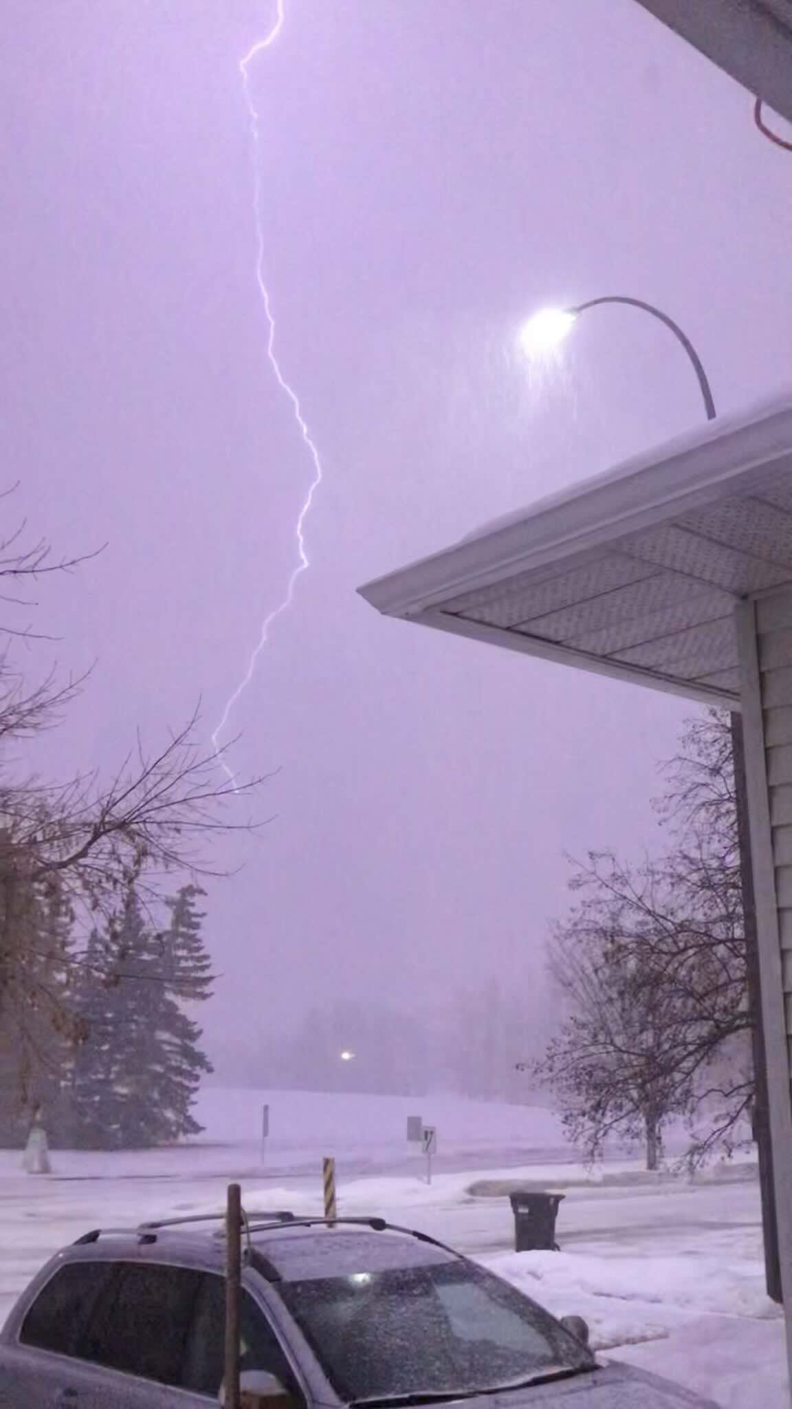 Source: Stephen West on Twitter
Another notable difference between these two weather phenomena is precipitation intensity. Thundersnow tends to produce heavy bursts of snowfall, which often quickly accumulates on the ground. This can reduce visibility and result in hazardous driving conditions. In contrast, regular snowstorms may have more moderate or steady rates of snowfall over an extended period.
The table below gives a quick summary of thundersnow vs. snowstorm differences.
| Thundersnow | Snowstorm |
|---|---|
| Thunder and lightning | No thunder and lightning |
| Heavy precipitation | Moderate precipitation |
The Science Behind Thundersnow
The formation of thundersnow is a complex process that requires specific atmospheric conditions, such as:
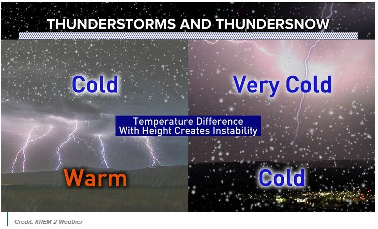
- Unstable atmosphere. Thundersnow occurs in an unstable atmosphere, just like in a typical thunderstorm. This instability is created when a mass of warm, moist air at the surface interacts with a mass of cold, dry air aloft.
Rising air. For thundersnow to happen, warm, moist air must rise rapidly, creating strong updrafts. This upward movement of air is essential for the development of both snow and lightning.
Ice crystal formation. As the moist air ascends and cools, it causes water droplets to freeze into ice crystals. These ice crystals may eventually clump together to form snowflakes. Additionally, ice crystals can collide with one another, creating an electric charge separation similar to what happens in a thunderstorm. When enough charge builds up, it can lead to lightning and thunder within the snowstorm.
Charge separation. As the ice crystals and supercooled water droplets collide and interact within the storm cloud, they create electrical charge separation. Like in regular thunderstorms, this separation builds up electrical potential energy.
Lightning and thunder. When the electrical potential energy reaches a critical point, it is discharged in the form of lightning. The lightning generates intense heat, which causes the air to rapidly expand and produce thunder, just like in an ordinary thunderstorm.
How to Predict Thundersnow
Since 2016, scientists have a new tool that can help them forecast thunder and lightning in snowstorm. It is a satellite instrument called the Geostationary Lightning Mapper, or GLM. This device can take pictures of lightning flashes over almost half of the Earth. In January 2016, astronaut Scott Kelly took a picture of a thunderstorm lightning strike on the International Space Station during Winter Storm Jonas. Here’s how it looked like:
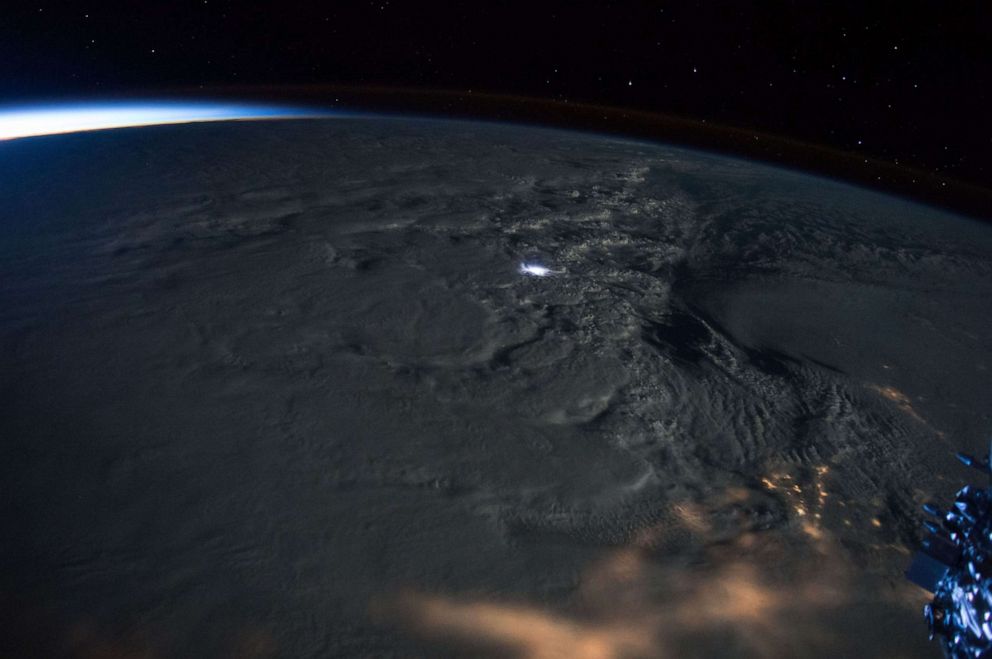 Source: Scott Kelly/NASA
Thanks to GLM, a group of researchers discovered that thundersnow flashes were bigger and lasted longer than ordinary lightning. The scientists also noticed changes in cloud tops similar to those that take place during a normal thunderstorm before lightning appears. The satellite images show how the cloud changes. First, the top of the cloud becomes icy. Then, the ice particles become smaller, probably because they break when they hit each other.
Where Does Thundersnow Occur
According to the NOAA National Severe Storms Laboratory, it’s possible to observe thundersnow downstream of the Great Salt Lake and Great Lakes during lake-effect snowstorms. Lake-effect snow happens when cold, dry air, typically coming from Canada, moves over the warmer waters of the Great Lakes. Thundersnow also happens in Nova Scotia and the Northeastern United States, especially in New England and New York.
Thundersnow is not very common in northwestern Europe, but it can happen in some places during winter and spring. For example, western Scotland had an episode of thundersnow in February 2018. The Met Office also warned of thundersnow in Scotland, Wales, and northern England in early January 2022.
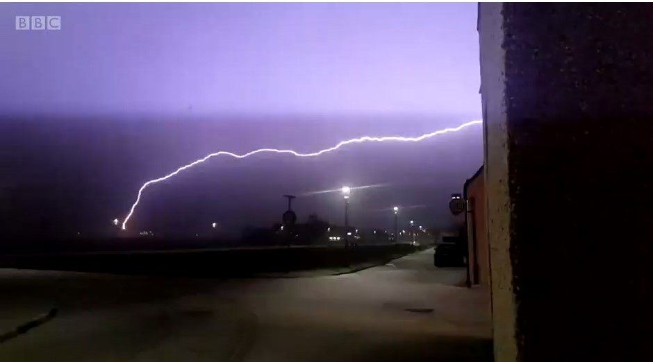 Source: BBC News Scotland
Thundersnow is even rarer in Western Europe. However, it did happen on March 8, 2010, when northeastern Catalonia, including Barcelona, had a lot of snow with lightning. In Central Europe, a large-scale thundersnow happened on January 17, 2022. A strong squall line moved from north to south over most of central and eastern Poland. It was dropping both snow pellets and snowflakes with over 100 lightning flashes per minute. Thundersnow can also happen around Kanazawa and the Sea of Japan, and even around Mount Everest.
How to Stay Safe During Thundersnow
When it comes to dealing with thundersnow, it’s important to prioritize safety and take the necessary precautions. One of the first things you should do is stay indoors if possible. Thundersnow can bring hazardous conditions, including heavy snowfall, strong winds, and lightning strikes. By staying inside, you can minimize your exposure to these risks and ensure your safety.
Additionally, it’s crucial to avoid any unnecessary travel during a thundersnow event. The combination of heavy snowfall and lightning can make roads extremely dangerous and increase the likelihood of accidents. If you must go outside, make sure to dress appropriately for the weather by wearing warm clothing and sturdy footwear. It’s also a good idea to have an emergency kit in your car that includes items such as blankets, food, water, and a flashlight.
Another important safety tip for dealing with thundersnow is to be cautious of potential power outages. Lightning strikes can cause electrical disruptions, so it’s advisable to have backup power sources available, such as generators, power banks, or battery-powered devices. It’s also essential to have a plan for communication during an outage. Make sure your cell phone is fully charged before the storm hits and consider having alternative means of communication like a landline or two-way radio.