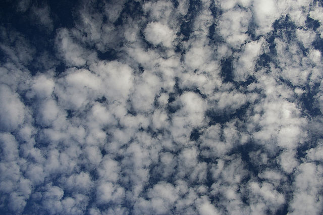
Clouds are an important aspect of daily weather patterns. They not only add beauty to the sky but also have a significant impact on the weather. A cloud can take many forms, from harmless sugar candy to a death-carrying monster, e.g. a tornado. In this article, we’re going to discuss how clouds form in the sky as well as explore various types of clouds and their characteristics.
How Clouds Are Formed
A cloud consists of water droplets that warm air has lifted from the Earth’s surface. Because the upper atmosphere is much colder than the lower one, the air there cools down rather quickly. The steam condenses and generates tiny particles of water and ice, which form white clouds. Therefore, we can say that every cloud is a kind of atmospheric moisture generator, through which water passes.
Like fog, a cloud forms by the condensation of water vapor into liquid and solid states. Condensation can happen due to either an increase in air humidity or a drop in temperature. Air temperature decreases because of the following two factors:
- the rise of air masses;
- the horizontal movement of air masses, known as advection.
So a temperature drop during an upward movement causes the formation of clouds. This process obviously differs from fog formation, because the fog does not rise, it remains at the ground level.
What makes the air rise? There are four reasons for that.
Air Convection
 Source: Energy Education
Cumulus and cumulonimbus clouds often have a convective origin. Here’s how convection works:
- On a hot day, the sun’s rays warm the earth’s surface.
- The earth’s surface transfers the heat to the ground-level air masses, causing them to rise.
- When the rise of air masses expands the air, cloud formation starts.
- The air rises quickly, and its volume leaves no time for the heat exchange between the rising air and the environment.
- Without receiving heat from outside, the air cools down. This process is known as adiabatic cooling.
- When the ascending air cools to the dew point, water vapor condenses and forms a cloud. The lower boundary of this cloud, also known as the condensation level, is determined by the height at which the vapor condenses.
- The air that continues to flow from below crosses the condensation level. As a result, the water vapor condenses already above this level, and the cloud begins to develop in height.
- When the rising air cools down and is no longer warm enough to rise, the cloud’s vertical growth will stop. At this point, a blurry upper boundary of the cloud will form.
Terrain
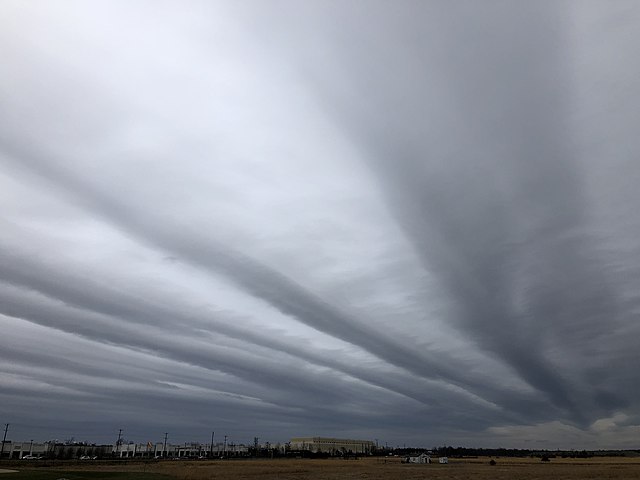
The wind blowing along the earth’s surface may meet mountains or other natural elevations on its way. Overcoming them, the warm, moist air masses rise whereas the dry, cold air masses descend. This process is called orographic lifting (from the Greek word oros, meaning “mountain”). Such clouds do not significantly develop in height, because they are limited by the terrain. In this case, stratus and nimbostratus clouds arise.
Fronts
The third reason for the rise of air masses is warm and cold weather fronts. Clouds form over warm fronts when warm air moves over cold air and rises along a wedge of receding cold air. The upward movement of warm air differs from the horizontal movement. As a result, the cloudiness arising above the cold wedge develops weakly in height but has a significant horizontal extent. Such clouds are known as upslip clouds.
A cloud also forms above a cold atmospheric front, when an advancing cold air mass moves under a mass of warm air and thus raises it. In this case, cumulus clouds may also form in addition to upslip clouds.
Cyclones
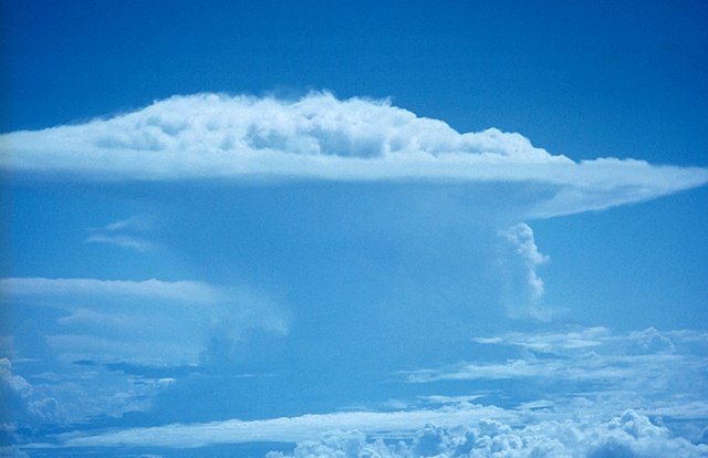 Image source: Wikipedia
Air masses, moving along the surface of the earth, twist towards the center of the depression in a cyclone. Accumulating there, they create a vertical drop of atmospheric pressure and rush upward. The rapid upward movement of air into the troposphere can result in the formation of cyclonic clouds. It can be nimbostratus, altostratus, and cumulonimbus clouds. All such clouds generate precipitation, creating rainy weather characteristics of a cyclone.
Types of Clouds
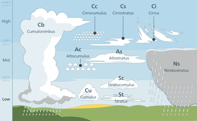 Image source: Valentin de Bruyn / CotonThis illustration has been created for Coton, the cloud identification guide for mobile., CC BY-SA 3.0, via Wikimedia Commons
The cloud development process also depends on the type of cloud, so now let’s discuss the types of clouds and their characteristics.
A cloud forms in the troposphere, so basically, we observe tropospheric clouds. They are divided into high, middle, low, and vertical development clouds. Almost all of them (except the last type) appear when moist, warm air rises.
| Type | Name | Altitude |
|---|---|---|
| Low | Cumulus Stratus Stratocumulus Nimbostratus | 164 to 6561 ft (0.05 to 2 km) |
| Middle | Altocumulus Altostratus | 1 to 4 mi (2 to 7 km) |
| High | Cirrus Cirrocumulus Cirrostratus | 4 to 8 mi (6-13 km) |
| Vertical | Cumulus Cumulonimbus | Up to 9 mi (14 km) |
Low Clouds
 Stratocumulus cloud. Source: Arun Kulshreshtha, CC BY 3.0 US, via Wikimedia Commons
A low-level cloud contains water droplets that freeze during the cold season and turn into particles of snow and ice. They are located rather low - at an altitude of 164 to 6561 ft (0.05 to 2 km) and look like a dense, low-hanging, gray cover.
Scientists categorize low-level clouds into cumulus, stratus, stratocumulus, and nimbostratus.
- Cumulus. Cumulus means “heap”, so these clouds look like wool. They are slightly transparent, white or gray, and darkened in places. Cumulus clouds can have the shape of a dome, cluster, or circle. When these clouds show up in the morning or evening, they can bring high winds and precipitation. If they arise at noon and dissolve by the evening, then the weather does not change.
- Stratus. “Stratus” means “layer”. These clouds are hazy or wavy, looking like a veil that gradually covers the skies. The thick gray stratus cloud is also called “high altitude fog” and usually brings rain. Stratus clouds contain a lot of water and sometimes give it off as drizzle or even snow.
- Stratocumulus. These are gray and/or whitish patches, patches, or layers of clouds composed of mosaic-like clumps, balls, or rolls. Stratocumulus clouds can occur in all kinds of weather conditions.
- Nimbostratus. This gray cloud layer is so dense that the sun cannot shine through. This type of cloud produces long-lasting precipitation.
Middle Clouds
Meteorologists rely on mid-level clouds to make weather predictions. These clouds can offer vital clues about weather patterns. For instance, when mid-level clouds become thicker and darker, it may signify that a storm is approaching. On the other hand, if these clouds start to thin out and break up, it could indicate that the weather is becoming milder.
In temperate and polar latitudes, mid-level clouds are located at a distance of 1 to 4 miles (2 to 7 km) above the Earth. In tropical latitudes, they can rise a little higher - up to 5 miles (8 km). All of them consist of water droplets mixed with ice crystals. Because of their small height, they mainly consist of water droplets during the warm season and ice crystals during the cold season. But precipitation from them does not reach the surface of our planet due to evaporation.
A mid-level cloud forms mainly when a cold front pushes a warm front up. And, although precipitation does not reach the ground, mid-level clouds mean a change in the weather (for example, a thunderstorm or snowfall). This is because cold air is much heavier than warm air. Moving along the Earth’s surface, it quickly displaces heated air masses up. Therefore, a sharp vertical rise in warm air forms mid-level clouds and then rain clouds.
Meteorologists distinguish between the following subtypes of mid-level clouds: altocumulus and altostratus.
- Altocumulus. This type of cloud has the form of scale-like parts, balls, or rolls. Altocumulus can also appear in the form of lentils (Lenticularis), which you can often observe near mountains.
- Altostratus. The altostratus is a layered cloud of mostly uniform appearance, covering all or part of the sky. The base of this cloud is up to 3 miles (5 km) wide and it may produce light rain.
 Altocumulus cloud. Source: Bidgee, CC BY-SA 3.0, via Wikimedia Commons
 Altostratus cloud. Source: Famartin, CC BY-SA 4.0, via Wikimedia Commons
High Clouds
High-level clouds are subdivided into cirrus, cirrocumulus, and cirrostratus. In the sky, such clouds look like feathers, waves, or a veil. All of them are translucent and let the sun’s rays through.
In middle latitudes, high-level clouds reach 4-8 miles (6-13 km), and in tropical latitudes, they reach 11 miles (18 km). Upper-level cloud movement varies with wind speed from 6 to 124 mph (10 to 200 km/h).
- Cirrus. “Cirrus” means a lock of hair or fiber. Cirrus clouds look like threads of cotton candy crossing the sky. These are the highest clouds in the sky, floating between 3 and 6 miles (5 and 10 km) above the ground and consisting of ice. They are often the precursors of bad weather, but it doesn’t rain from them.
- Cirrocumulus. Cirrocumulus (Lat. cirrus “lock of hair “ + cumulus “heap”) is a type of high cloud that floats at altitudes between 4 and 7 miles (6 and 11 km). These clouds resemble thin, white patches, feathers, or layers.
- Cirrostratus. This type of cloud looks like a thin, whitish cover. Its name is translated from Latin as “lock of hair” + “layer”. Sometimes cirrostratus clouds are almost imperceptible and only give the sky a whitish tint, and sometimes they look like threads. They can be both extremely thin and quite dense, which means that it is harder for light to break through them. Forming at an altitude of 3 to 8 miles (5 to 13 km), cirrostratus clouds cause the formation of halos around the sun (parhelion) and the moon (parselena).
Vertical Development Clouds
These are cumulus and cumulonimbus clouds that can form at a fairly high altitude - up to 9 miles (14 km). Their lower levels contain water whereas the upper ones contain ice crystals. The darker they are, the more moisture they contain, because the sun’s rays cannot shine through the water obstacle. Water droplets from the lower part of the cloud rise to the upper layer, where they turn into ice, and then descend. The ice particles are enveloped in water and rise where they freeze again. This is how hail forms.
Unlike other clouds, a cumulonimbus cloud forms only with a very rapid vertical rise of moist air:
- Humid warm air rises intensively.
- At the top, water droplets freeze.
- The upper part of the cloud becomes heavier, lowers, and stretches towards the wind.
How Long Do Clouds Live?
The life of a cloud directly depends on air humidity. If it is low, it evaporates quite quickly. For example, some clouds live no longer than 10-15 minutes. High humidity can prolong a cloud’s lifespan until it meets specific conditions and precipitates.
No matter how long a cloud lives, its state is constantly changing. The particles that make it up are constantly evaporating and reappearing. Even if at first sight the cloud does not change its height, it constantly moves. This is because the droplets in it descend, pass into the air under the cloud, and evaporate.
Summary
Clouds are a critical component of meteorology because they influence weather patterns, temperature, and precipitation levels. Meteorologists use cloud observations to predict weather patterns, as different types of clouds can indicate different atmospheric conditions. For example, low, thick clouds are often a sign of rainy or stormy weather, while high, thin clouds can indicate mild weather conditions.
Cloud cover can also affect temperature by blocking or reflecting sunlight, which in turn can impact wind patterns and precipitation. Understanding cloud formation and behavior is essential for predicting weather and climate changes.