
When listening to a weather forecast on the radio or TV, you may often hear that a weather front may cause low air temperature, precipitation, or strong winds. But what is a front, how does it form, and what are the types of fronts? Let’s find out in this article.
History of Weather Fronts
At the beginning of the 20th century, the school of Norwegian scientists introduced the concepts of “air mass”, “front”, “cyclone”, and “anticyclone” in weather forecasting. The need for more accurate forecasts was due to historical events, specifically World War I, when the military began using aircraft. Then Norwegian weather forecasters were actively studying the structure of the atmosphere and dangerous natural phenomena associated with it. As a result, they discovered such “synoptic objects” as air masses and weather fronts, whose movement is closely related to atmospheric vortices, high and low pressure zones, cyclones, and anticyclones.
Formation of a Weather Front
The atmosphere of our planet is made up of huge volumes of air called air masses. Inside the air masses, the main meteorological parameters, such as temperature and moisture content, change insignificantly. But at the boundary between two air masses, these parameters can change dramatically. For example, at a distance of several hundred miles, the temperature can change not by 33-35 °F, but by 50-60 °F.
Warm and cold air masses are always present in the atmosphere and have different properties. During the year, the equator and the pole have varying temperatures, and the heat on the Earth’s surface is unevenly distributed. The dividing zone between the warmer and colder air masses is called a front. Fronts can move, become active, blur, and even disappear, and “waves” can appear on them - bends in the boundary line, which also move.
The front separates warmer and colder air, and both warm and cold air masses can arrive. A warm front forms when a warm air mass occupies those spaces that were previously captured by cold air. If there is a movement of a cold air mass and cooling is observed, then it is a cold front. Significant weather changes, dangerous natural phenomena such as thunderstorms, squalls, hail, ice formation, and, finally, intense precipitation, are associated with weather fronts.
Types of Fronts
Meteorologists distinguish between the warm, cold, occluded, and stationary fronts. On the weather map, a warm front is marked as a red line with half-circles. A cold front is represented by a blue line with triangles. A line with alternating red half-circles and blue triangles depicts a stationary front whereas a purple line with purple half circles and triangles shows an occluded front.
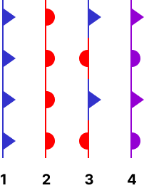 Image source: Wikipedia
Now let’s explore the characteristics of each front type.
Warm Fronts
 Image source: The Great Cloudwatcher, CC BY-SA 3.0
, via Wikimedia Commons
Image source: The Great Cloudwatcher, CC BY-SA 3.0
, via Wikimedia Commons
In the case of a warm front, warm air flows into a wedge of cold air and begins to slowly rise along this wedge. The rise occurs over vast expanses, because the separation zones between the air masses are thousands of kilometers long. And with such a calm, slow, large-scale rise, stratus clouds form. These are:
- cirrostratus clouds (they are the highest and occur at an altitude of more than 3 miles),
- altostratus clouds (mid-level sheets of thin cloud cover),
- and nimbostratus clouds (low stratus clouds of dark color)
Together, they form a giant cloud system. The horizontal length of the clouds reaches several thousand miles. The width of the cloudy zone in the region of the warm front is about 600 miles before the front passes. Unlike cold fronts, warm fronts do not contain any dense air. Therefore, warm fronts tend to bring more moderate and long-lasting weather patterns, such as light rain. After the front has passed, when a warmer air mass arrives, the precipitation stops. However, the weather does not immediately improve: such a large cloud system cannot collapse instantly. Therefore, cumulus clouds appear, and fogs often form.
Cold Fronts
 Image source: Ugglewug, CC BY-SA 4.0
, via Wikimedia Commons
Image source: Ugglewug, CC BY-SA 4.0
, via Wikimedia Commons
On the cold front, things don’t work that way. The advancing cold air descends, and by the nature of its movement, it is similar to the approaching caterpillar of a tractor. As the cold air descends, it pushes the warmer air up, and this upward motion is very intensive. As a result, warm air rises very quickly ahead of the front, forming tower-like clouds. These clouds are called cumulonimbus. They spread to high altitudes, to the entire troposphere, with a height of 6-7 miles, causing short but intense rain showers.
The so-called charges are associated with cold fronts. Intense precipitation passes, then a short-term clearing occurs, followed by the next line of precipitation. Due to an intense expulsion of warm air, wind gusts can accompany such processes. Therefore, cold fronts can cause a sharp increase in wind direction and speeds, sometimes reaching the speeds of tropical storms and even hurricanes.
The movement of a cold front through a warm front is usually called a low-pressure system. Low-pressure systems often cause severe rainfall or thunderstorms. Therefore, the attention of weather forecasters is always focused on the approaching of a cold front, so that they can issue a storm warning.
Warm front vs. cold front characteristics:
| Warm front | Cold front |
|---|---|
| Warm air moves through cold air. | Cold air moves through warm air. |
| Warm air goes up. | Cold air pushes warm air upward. |
| Long-lasting rains. | Showers and thunderstorms. |
| Slow rise of temperature. | Quick lowering of temperature, clear sky. |
Stationary Fronts
Stationary fronts are fronts with a non-shifting air mass. The location of such fronts is a hollow, saddle, or on the anticyclone periphery. The stationary front is accompanied by cirrostratus, stratus, and nimbostratus clouds. During the summer months, cumulonimbus clouds cover the sky. The wind and air pressure do not change, and the wind is quieter in the cold part. A narrow strip of the front is covered with heavy rain. In the case of a changing wind direction, a stationary front can transform into either a cold or a warm front.
Occluded Fronts
Because the cold air descends and moves forward, the cold front moves faster than the warm one. It means that the cold front can be ahead of the warm front. If it happens, the cloud systems of both fronts close, and a so-called occluded front occurs, which causes the longest and most intense precipitation.
There are two types of occluded fronts - cold and warm. A cold occlusion happens when there is cooler air behind the occluded front and warmer air ahead. Conversely, warm occlusions take place when the air behind the front is warmer than the air ahead.
Occluded fronts cause unpleasant consequences for aviation. Cumulonimbus clouds, which are associated with dangerous natural phenomena, hide in an array of stratus clouds that form during a warm front. This phenomenon is called masked convection. These clouds are not visible to the naked eye - only radars can detect them. If you have planned an air journey and hear about an occluded front in a weather forecast, then be prepared that your flight may be delayed due to adverse weather conditions.
Conclusion
The approaching of a weather front is associated with weather changes and dangerous phenomena due to the interaction of two different air masses, warm and cold. The detection of atmospheric fronts is one of the main tasks of weather forecasters, but despite this, there are still no models that independently predict weather fronts. However, it is still possible to get warnings about dangerous weather conditions that the fronts can cause.
With RainViewer, you can get timely alerts about heavy rains, storms, hurricanes, extreme heat, or low temperatures. The Severe Weather Alerts functionality delivers warnings from local weather agencies directly to your smartphone and shows these weather events on a map. Please do not ignore these warnings and stay safe.


