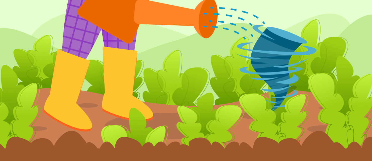
A tornado is a terrifying weather phenomenon with great destructive power, capable of uprooting trees, tearing off roofs from houses, and lifting cars into the air. A tornado is also a mysterious phenomenon that is quite difficult to predict - it comes from nowhere and goes nowhere. In this article, we will try to figure out how a tornado forms and what it consists of.
Anatomy of a Tornado
A tornado is a funnel cloud that descends from a thunderstorm cumulonimbus cloud. The air inside the funnel rotates in a spiral updraft. At the bottom of the funnel, the suction power is so high that it can lift objects and destroy them. A debris cloud at the funnel’s bottom is sometimes even visible on radars.
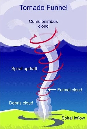 Image source: Prepp
Tornado clouds, like other thunderstorm cumulonimbus clouds, are heterogenous and highly turbulent. Most tornadoes have a vortex structure. If the funnel has not reached the ground, then you may not see it. But as a rule, the whirlwind captures water and dust during its movement, and the funnel becomes clearly visible.
Wind speeds inside the funnel approach the speed of sound (about 745 mph), and the funnel itself moves at 24 mph. On the outside, the funnel resembles a cone-shaped cloud column, towards which another cone rises from the ground. This cone consists of dust, water, and flying debris, spiraling upward to the base of the cumulonimbus cloud. Funnel shapes are unusually varied and change rapidly even within the same tornado. Wide and low blurry whirlwinds are the most destructive. They cover more territory than dense tornadoes and do more damage.
The destruction from tornadoes is enormous, not only because of the huge speed of air masses, but also due to the rapidly changing atmospheric pressure. A tornado is similar in structure to a miniature tropical storm. Both a storm and a tornado contain a space more or less limited by “walls”. It is almost clean and cloudless, sometimes small lightning flashes from wall to wall. In the center of the funnel, the air pressure is lower than at the edges. In seconds, the pressure can change by tens of millibars. So if buildings with closed windows stand in the way of a tornado, they seem to explode from the inside, whereas walls and windows lean outward.
 Damage from a tornado in Arabi, Louisiana. Image source: CNN
How Tornadoes Form?
A whirlwind forms over flat land. In such zones, the bottom layer of air warms up from the warm earth, but above the earth, the air remains cold. Warm, humid air at the ground level meeting the cold, dry air at higher altitudes can cause a shear - a rapid change of wind speed and direction.
When two air masses meet, cold air is heavier than warm air and thus sinks strongly. In turn, warm air rises rapidly from the ground. This movement initially creates thunderclouds. Additionally, vertical air currents arise, reaching a diameter of about 6 miles.
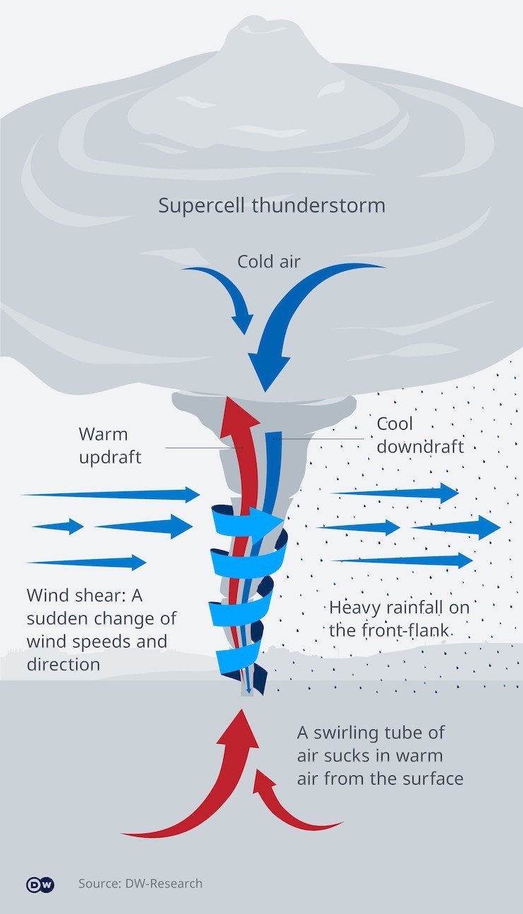 Image source: DW.com
If several thunderclouds join together, they form a so-called supercell. If winds at altitude blow from different directions than winds on the ground, a vortex develops. The violently rotating column of rising warm air creates a powerful suction. It has the power to cover the roofs of houses or to sweep cars up with it. If a tornado hits the water, it can also pick up water droplets and whirl them along. That is why it is sometimes called a waterspout.
Waterspouts are more common in tropical latitudes. In contrast to a classic tornado, a waterspout lasts 15-30 minutes and is much smaller in diameter. It moves and rotates two or three times slower, and high winds do not accompany it. Even though waterspouts are typically born in tropical latitudes, they appear in temperate latitudes as well. They can often occur on the west coast of Europe, in the British Isles, and in some areas of the Mediterranean. Waterspouts are not limited to saltwater bodies. Many can form over lakes and rivers, for example, over the Great Lakes.
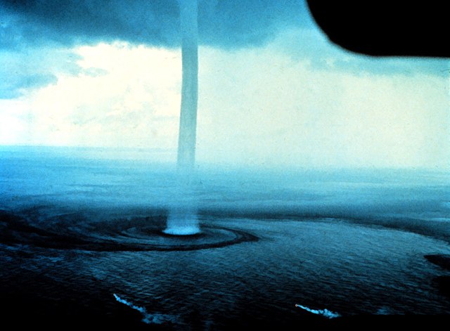 Image source: Wikipedia
One of the most important and interesting properties of a tornado is its sharp limitation in space with the presence of almost smooth dense walls. No other atmospheric formations have such sharp boundaries, except for lightning, which moves even faster. The reason for the appearance of a sharp boundary may be unusually high speeds. Lifting and carrying heavy objects shows that the peripheral speeds in the funnel change rapidly and significantly. The bottom of the funnel can spin faster than the top and lift heavy objects, but the lifting height does not exceed a mile. Higher up, the rotation becomes slower. Large objects are ejected from the funnel and fall down.
Types of Tornadoes
Basically, there are two types of tornadoes.
Type I tornadoes emerge in the case of strong vertical wind shear and rotating thunderstorms (mesocyclones), hence called mesocyclonic tornadoes. In the case of prolonged rotation, they may be called supercell tornadoes. Most of them exist over land, but they can also appear over water. Tornadoes of the first type require vertical wind shear as the main ingredient. The further necessary directional shear is created either by a simultaneous wind shift with height or by a deviating track of the thunderstorm, which thereby “collects” directional shear. Together, directional change and shear produce helicity (spiraling), the ability of an updraft to rotate.
Type II tornadoes form in weak vertical shear, typically at the early stages of showers or thunderstorms on a convergence line near the ground. They are therefore called non-mesocyclonic tornadoes (formerly non-supercell tornadoes). Unlike Type I tornadoes, this type does not necessarily require violent storms or strong wind shear. They need a convective cloud whose updraft is strong enough to stretch a vertical vortex and a ground-level convergence zone where winds of different directions converge.
A Tornado Has Formed. What Happens Next?
Like many natural phenomena, tornadoes go through several stages of development. In the beginning, an initial funnel appears from a thundercloud. It happens due to the potential energy accumulated during the rising of air. This energy converts into kinetic energy at first vertical and then rotational motion. After that, the circumferential speed of the tornado increases, and it acquires its classical form.
Each stage lasts about several minutes. In very rare cases, a tornado can exist for several hours. The speed of tornadoes also varies. Sometimes the cloud moves very slowly, almost standing still, and sometimes it rushes very fast. Meteorologists determine the average speed of tornadoes at 24-37 miles per hour, but sometimes it reaches 124 miles per hour. During its movement, a tornado travels a path equal to an average of 12-18 miles. However, it is common for tornadoes to travel distances of 62-74 miles. Giant tornadoes can travel up to 300 miles, but these are exceptional phenomena.
The intensity of whirlwinds is measured by the Enhanced Fujita Scale (EF Scale) and depends on the speed of a 3-second gust in miles per hour.
|EF SCALE||
| EF Rating | 3 Second Gust (mph) |
|---|---|
| 0 | 65-85 |
| 1 | 86-110 |
| 2 | 111-135 |
| 3 | 136-165 |
| 4 | 166-200 |
| 5 | Over 200 |
Table source: National Weather Service
An interesting feature of tornadoes is their “jumping” or “skipping”. After passing a certain distance on the ground, they rise and rush through the air without causing any destruction. Then they go down again and cause damage, then rise again, leaving behind a discontinuous path of destruction.
Why and when does a tornado stop? There is no clear answer to this question. Scientists believe that a tornado stops because the spinning air in the funnel cloud gets too cold and thus the tornado loses its energy and dissipates. However, thunderstorms that produce tornadoes can last quite long even after the tornado disappears.
Where Are Violent Tornadoes Most Common?
The United States very often appears in the news about tornadoes. The National Weather Service records about 1,000 tornado events per year with about 240 victims and $14 million in damage. The tornado season in the US typically lasts from March to June.
According to Fox Weather , here are the average monthly tornadoes between 1991 and 2020, with May being the most active month:
| Month | Number of Tornado Events |
|---|---|
| January | 45 |
| February | 44 |
| March | 92 |
| April | 212 |
| May | 294 |
| June | 212 |
| July | 116 |
| August | 87 |
| September | 70 |
| October | 64 |
| November | 65 |
| December | 32 |
American meteorologists introduced the term “tornado alley” - the favorite route of most tornadoes. This route runs from north to south of the United States almost along the center of the Great Plains from North Dakota, Minnesota, Nebraska, and Iowa through Kansas to Texas.
A tornado is also a frequent guest in Argentina, India, and Japan. For example, in April 2021, in the department of Malargüe, located in the southern part of the Argentine province of Mendoza, witnesses noticed a strong tornado. Locals managed to film the spinning vortex and shared the video on Facebook . Fortunately, there were no buildings in the path of the tornado, and no damage or injuries were reported. After the tornado passed, it began to rain with hail.
How to Stay Safe During a Tornado
In 2021, the “13 Minutes” movie was released. According to its plot, the residents of a small provincial town have 13 minutes to seek shelter. Of course, this is not an exact timing, but a tornado can indeed occur “out of the blue”, not allowing you much time for evacuation.
Nowadays, it is possible to spot a tornado on the radar . When a tornado is about to appear, a thunderstorm produces the so-called hook echo, which is visible on the Doppler radar. Additionally, green and red colors indicate alternating wind speeds that are also a sign of an approaching tornado. Finally, radars can spot even debris clouds and rotating objects on the map.
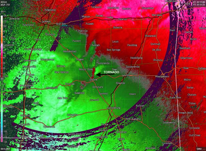 Image source: Illinois State Climatologist
Based on the radar data, a local meteorological agency issues a tornado warning. The RainViewer app can track those warnings and deliver the alerts directly to your smartphone. It is also possible to track tornadoes on our built-in radar map. The RainViewer map shows a tornado as a small pink area surrounded by a larger blue area.
If you live in an area where weather conditions are favorable for tornado events, please do not ignore warnings and immediately hurry to the nearest shelter. Stay safe!


