
Foggy weather has always fascinated and inspired humankind. From the mysterious landscapes of Gothic novels to the romantic scenes of Hollywood movies, fog has been a powerful element of storytelling and imagination. But what is fog exactly? How does it form and disappear? And how does it affect our lives and activities? In this article, we will explore the science of fog, starting with the fog definition.
Fog Formation Process
Fog forms under two main conditions – increasing moisture and/or cooling of the air.
Fog is like clouds, but it happens near the ground instead of high up in the sky. For fog and clouds to appear, the air has to cool down to the point where water vapor turns into tiny water droplets. This is called the dew-point temperature and it depends on how much moisture is in the air.
The air usually cools down at night when the ground gives off the heat it got from the sun during the day. This happens more often when the weather is calm and clear because of a high pressure system.
Fog is a type of cloud that forms close to the ground when the air is filled with tiny droplets of water or ice. The air cools down quickly and cannot hold as much moisture as before. As a result, the water vapor turns into small particles that stay near the surface. Fogs appear in certain weather situations, such as when warm, humid air meets a cooler surface. It can also appear when moist air travels over a colder body of water. Although autumn and winter are the main seasons for foggy conditions, they can occur all year round.
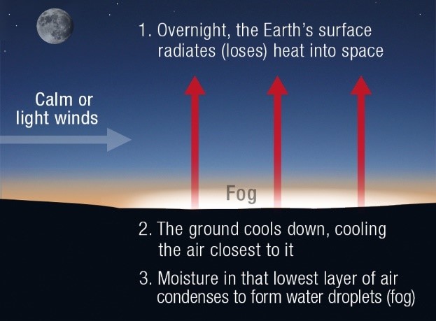 Image source: Bureau of Meteorology
But not every high pressure system makes fog. Sometimes the conditions are not right. If the wind is too strong, low clouds form instead of fog. If the wind is too weak or none at all, dew forms on the grass instead.
The other important factor in fog formation is how much moisture is in the air. The higher the dew-point temperature, the more water vapor is in the air. For fog to form, the air temperature and dew-point temperature have to be very close to each other. If they are—and the wind is just right—then fog is very likely to form.
Fog dissipates when the air gets drier and warmer than the dew point by absorbing the sun’s rays or moving over a hot surface. Strong winds can also remove foggy conditions.
The table below summarizes the fog formation and dissipation processes:
| Process | Conditions | Causes |
|---|---|---|
| Formation | Moisture |
|
| Air cooling |
| |
| Dissipation | Dry air |
|
| Heating of the air |
|
Foggy weather can last for a long time under these conditions:
- Weak solar radiation. Between mid-October and early February, this is the case due to the low position of the sun.
- Weak winds in the lower air layers.
- Thin cloud cover. This condition is met in high-pressure weather.
- A “basin” for the moist cold air to gather in.
Types of Fog
Meteorologists distinguish between the following types of fog:
Radiation
This is the most common type of fog, also known as the ground fog. It occurs mainly in autumn during low-wind or windless high-pressure weather conditions. In this case, the ground and the air above it get colder than the dew point because of night-time cooling under clear skies.
Evaporative
This kind of fog happens when water vapor fills up the air mostly because of evaporation. You can see this type of fog over warm water that gives off water vapor into a colder air mass above it (like a sea, lake, or river).
Mixed
In mixed fog, warmer air mixes with colder air. Mixed fogs typically occur near warm weather fronts. The air layer near the ground gets more moisture by evaporation of the rain from the front. You can make mixed fog yourself on a small scale. Just breathe out into the cold air on a winter day, and the water vapor will turn into tiny droplets right away. The little cloud you see is actually a mixed fog.
Advection
Moist warm air flowing from warmer to colder regions over colder surfaces and stirring up layers of cold air close to the ground causes advection fogs. The warm air cools in such a way that the water within it condenses and the droplets form. In stable high-pressure conditions without precipitation, advection fogs can last for days or even weeks.
Orographic
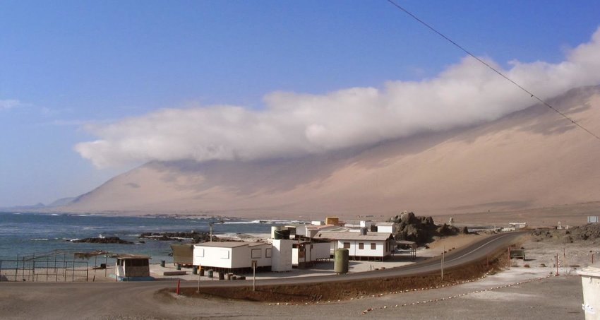 Image source: Larraín, H.; http://ecoantropologia.blogspot.com
Orographic fogs are also called mountain fogs. They form when moist air rises on mountain slopes and cools with increasing altitude and lowering atmospheric pressure. Orographic fogs exist where winds consistently bring air masses close to mountains. The more stable this air current is, the more low-lying clouds can cool down on the slope and form beautiful foggy landscapes.
Ice
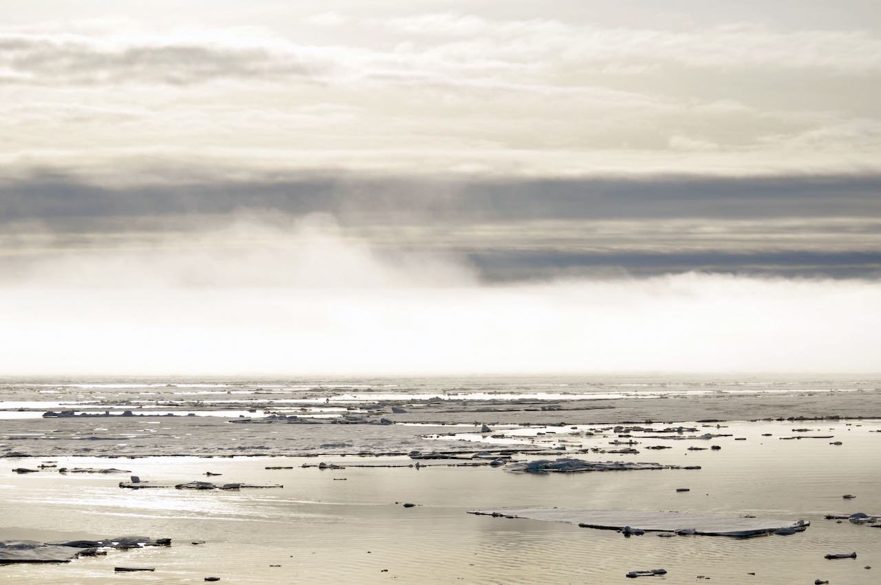 Image source: USGS, Partick Kelley
Unlike normal fog, ice fogs have tiny ice crystals floating in the air instead of water droplets. Ice fog only forms when the temperature is -4°F (-20°C). A combination of extremely low temperatures and large amounts of water provides perfect conditions for ice fog formation. For example, it forms over the Arctic Ocean, in Alaska, and in the Norwegian fjords.
Why Is It Difficult to Forecast Fog?
To improve fog forecasting, meteorologists rely on a combination of observational data and numerical weather prediction models. However, due to the inherent complexities and uncertainties associated with fog, it remains a challenging aspect of weather forecasting. Here are some reasons why fog prediction is difficult:
- Complex atmospheric conditions. Fog formation depends on temperature, humidity, wind speed, and stability of the air. These factors can change quickly and vary over small distances, impeding the fog monitoring.
- Microscale nature. Fog is a microscale atmospheric phenomenon, meaning it occurs on a relatively small spatial scale. It can develop and dissipate over a localized area, making it difficult to pinpoint its exact location and duration. Forecast models typically operate on larger scales and might not capture the intricate details of fog formation in specific regions.
- Temporal variability. Diurnal variations in temperature and other atmospheric parameters influence fog formation. It often occurs during the night or early morning when the land surface cools, causing the air above it to cool and reach its dew point. These changes make it hard to accurately predict when foggy weather will start and end.
- Topography. Local topography, such as hills, valleys, lakes, etc. can significantly impact fog formation. These features can create microclimates where fog is more likely to occur due to variations in temperature, wind patterns, and moisture distribution. Forecast models may struggle to accurately predict these localized effects.
- Observation limitations. Fog is often associated with reduced visibility, which can hinder direct observations and measurements. Limited fog visibility makes it challenging to gather real-time data about fog formation and track its evolution.
- Uncertain interactions. Fog formation involves complex interactions between various atmospheric processes, such as radiative cooling, advection, and condensation. Meteorologists don’t know everything about these interactions yet, so they cannot be sure when and how fog will happen.
What Are the Effects of Fog on Air Quality?
Foggy atmospheric conditions can have both positive and negative effects on the quality of the air, depending on the specific circumstances.
Particulate Matter Trapping
Fog can act as a medium for trapping and suspending particulate matter in the air, such as dust, soot, and pollutants. When fog forms, these particles can become trapped within the droplets, effectively increasing their concentration in the air. This can lead to degraded quality of the air and potential health risks.
Dilution and Dispersion of Pollutants
On the positive side, fog can help dilute and disperse pollutants in the atmosphere. When fog forms, it mixes with the surrounding air, potentially reducing the concentration of pollutants. This dispersion effect can be beneficial in urban areas with high pollution levels.
Chemical Reactions
Fog droplets can undergo chemical reactions with certain atmospheric pollutants. These reactions can lead to the formation of new compounds, some of which may badly impact air quality. For example, the reaction of droplets with nitrogen oxides (NOx) can contribute to the formation of acidic compounds.
Moisture Supply
Fog provides a source of moisture to the environment, particularly in arid regions. The moisture from fog can contribute to the hydration of plants and soils, which is essential for maintaining ecosystem health and supporting agricultural activities.
Here’s an example of fog’s impact on air quality. In California’s Central Valley, a weather phenomenon called tule fog has decreased over the last 30 years. According to scientists at the University of California, Berkeley, the decreasing levels of air pollution were the case.
 Image source: Steve Corey via Flickr
Effects of foggy weather patterns on the air can vary depending on the fog composition, the presence of pollutants, and the local atmospheric conditions. Fog alone is not bad for the air, but it can interact with pollutants and make them worse or spread them around. Monitoring and understanding these interactions is crucial for analyzing the overall impact of fog on air quality.