
Weather constantly amazes us. From stunning sunsets to terrifying thunderstorms, there’s always something happening in the sky. But did you know that some weather phenomena are lesser-known, yet just as fascinating? In this article, we’ll describe some of these weather mysteries. Let’s start with a brief summary.
| Weather phenomenon | Short description | First record |
|---|---|---|
| Mammatus clouds | Clouds looking like bubbles | 1894 |
| Arcus clouds | Horizontal, band-like cloud formations | 1942 |
| Ball lightning | Lightning looking like a ball that can move | 1638 |
| Frost flowers | Ice formations on the ground | 1833 |
| Virga | Precipitation that evaporates before reaching the ground | No record |
| Sun dogs | A halo that looks like a second sun | 384-322 BC |
| Brinicles | Underwater ice stalactites | 1960 |
Now let’s take a closer look at each of these weather phenomena.
Mammatus Clouds
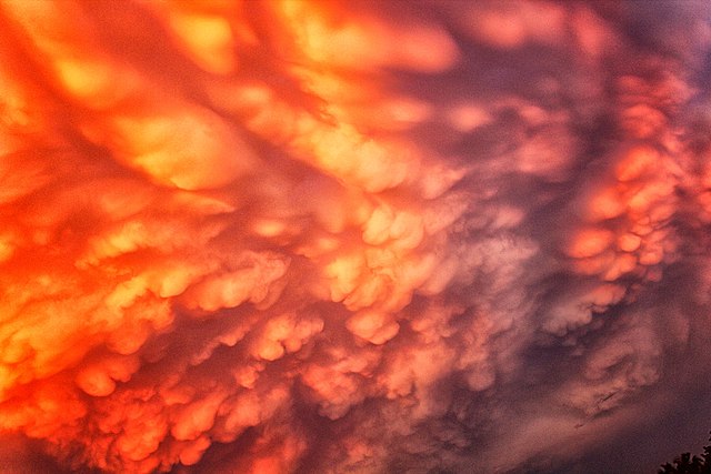 Image source: Riazmusthafa, CC BY-SA 4.0
, via Wikimedia Commons
Image source: Riazmusthafa, CC BY-SA 4.0
, via Wikimedia Commons
You’ve probably seen pictures of these ominous-looking clouds before. Mammatus clouds are weather phenomena that resemble a huge bubble wrap stuck to the cloud base. They are typically smooth on the bottom and have a more textured appearance on the top.
Mammatus clouds form when cold, sinking air pockets push the cloud base, causing it to bulge and create distinctive pouch-like shapes. They often appear during or after thunderstorms, and while they look menacing, they’re mostly harmless. Scientists still don’t fully understand how they form, but their formation may result from the interaction between updrafts and downdrafts within a storm.
Arcus Clouds
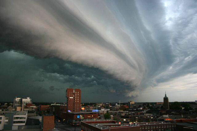 Image source: John Kerstholt, CC BY-SA 4.0
, via Wikimedia Commons
Image source: John Kerstholt, CC BY-SA 4.0
, via Wikimedia Commons
Also known as a morning glory cloud, arcus is a type of low-level, horizontal cloud formation. It appears as a long, low, horizontal band of cloud. These weather anomalies often have a distinct wedge or arch-like shape, hence the name “arcus,” which is Latin for “arch.”
Here’s how these clouds form:
- A thunderstorm with strong outflow winds (a gust front) occurs.
- As the gust front advances, it lifts warm, moist air.
- An outflow boundary looking like a dark, rolling cloud between the cooler and the warmer air appears.
When the outflow boundary meets low-level moisture, it can create a characteristic “shelf cloud” extending along the leading edge of the arcus cloud. The shelf cloud can be quite striking, with a dark, ominous appearance.
The most recent shelf cloud appeared on April 19, 2022, in Istanbul. In this video , you can see how the city was swallowed by darkness in broad daylight.
Ball Lightning
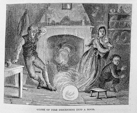 Image source: Wikipedia
Ball lightning belongs to rare and mysterious weather events that have been reported by witnesses for centuries. It’s a small, glowing sphere of light that appears during thunderstorms and can float or bounce along the ground for several seconds.
It is not surprising that religious or superstitious people look at the glowing fireball suspiciously. After all, there are various reports of ball lightning associated with churches.
The first documented ball lightning strike hit a church in England in 1638 during an afternoon mass with 300 worshippers. It pierced the window, killing four people and injuring about 60 others. The church itself was badly damaged. No wonder the event has since been blamed on the devil in local legends.
Despite numerous reports of ball lightning, scientists have struggled to explain what causes these strange weather phenomena. Some theories suggest it’s related to the electrical discharge that occurs during a lightning strike, while others think it could be a type of plasma.
Frost Flowers
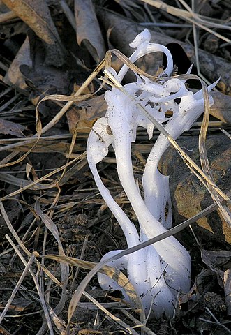 Image source: Slomoz, CC BY-SA 2.0
, via Wikimedia Commons
Image source: Slomoz, CC BY-SA 2.0
, via Wikimedia Commons
Frost flowers are delicate, intricately patterned formations that can appear on the ground during cold weather. They form when moisture in the ground freezes and expands, pushing through the soil in thin, delicate ribbons. The ice crystals then take flower-like shapes that can be incredibly beautiful.
Frost flowers can only form under specific conditions, such as when the air is cold and dry, and the ground is not frozen. Here’s how they form:
- The temperature drops and the moisture in the plant’s stem or leaves freezes.
- The water expands and pushes out through small cracks in the surface.
- The water creates thin ice layers that gradually build up into frost flowers.
These incredible weather phenomena are not only a wonder to behold, but they also have ecological significance. Frost flowers can be a source of moisture for animals and plants during the winter months when other water sources may be scarce. They can also help to insulate the plants and protect them from the cold, acting as a natural barrier against low temperatures.
Virga
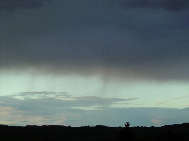 Image source: Simon Eugster (talk · contribs), CC BY-SA 3.0
, via Wikimedia Commons
Image source: Simon Eugster (talk · contribs), CC BY-SA 3.0
, via Wikimedia Commons
Have you ever seen rain falling from a cloud, but never reaching the ground? This weather phenomenon is known as virga. It occurs when rain falls from a cloud but evaporates before it reaches the ground.
Virga is a sign of dry air, which means that no powerful cloud with large heavy raindrops can form. It can create stunning visual effects as the rain falls through the air. For example, you can observe how the cloud itself thins out and slowly dissipates as if it has fallen from the sky. Virga can also occur in higher clouds when ice crystals evaporate.
Sun Dogs
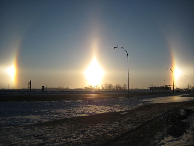 Image source: Wikipedia
Sun dogs, also known as parhelia, are bright spots that can appear on either side of the sun. These weather phenomena occur when sunlight is refracted through ice crystals in the atmosphere. The result is a bright spot of light that looks like a second sun.
Sun dogs are more common in colder regions, where there are more ice crystals in the air. A similar light phenomenon can appear near the moon. However, due to the lower luminous intensity, the secondary moon is seen less often, mostly only at full moon.
Although parhelia often show colors similar to rainbows, they must not be confused with them. Secondary suns appear near the sun whereas rainbows appear on the side of the sky opposite to the sun. The cause of the optical atmospheric phenomena is water droplets for rainbows and ice crystals for parhelia.
Brinicles
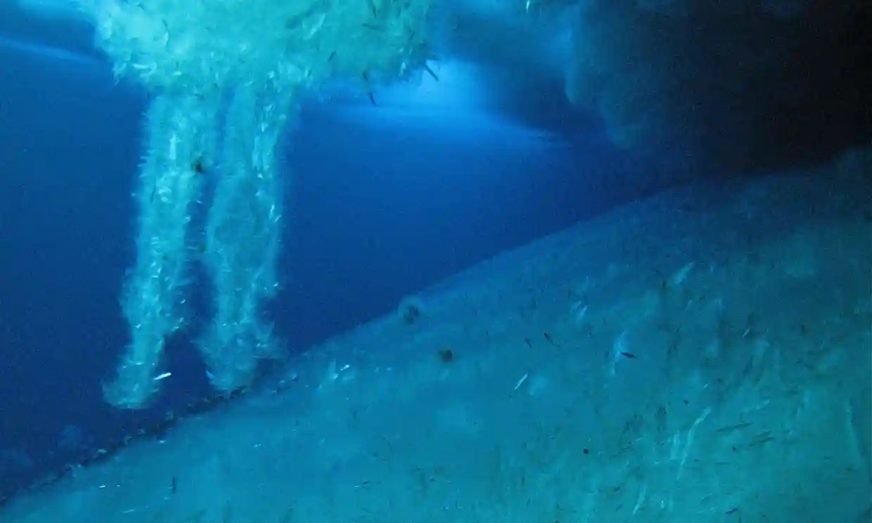 Image source: The Guardian
A brinicle, also known as an ice stalactite, belongs to unique weather phenomena that occur in extremely cold and saline water conditions. It forms when seawater with a very low temperature and high salinity begins to freeze and sink downwards, creating a downward icicle-like structure. As the brinicle descends, it leaves behind a trail of ice on the sea floor, which spreads out and forms a disc-like shape.
Brinicles form in polar regions where the temperature is cold enough to freeze seawater, and the water salinity is high enough to lower its freezing point. These weather conditions typically occur in the shallow waters around the coast, where freezing air temperature affects seawater. A brinicle can freeze anything it comes into contact with, including seafloor organisms and even seawater itself.
Conclusion
These are just a few of the fascinating weather events that can occur around the world. While some of these natural phenomena can be dangerous, they’re all incredibly intriguing and remind us of the awe-inspiring power of nature.


