
Imagine you are enjoying an exciting outdoor adventure that requires clear skies. You see rain or snow in the forecast and want to check its movement on RainViewer’s radar map. You open the map and - oh no! - see that your area is out of radar range. This used to be a problem, but not anymore as our map goes global.
Weather Radar Coverage Challenges
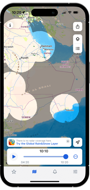
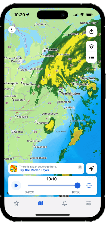
There are many weather radar stations across the globe, but there are also radar-free areas, such as oceans or deserts. Additionally, even within the coverage area, the radar may not “see” precipitation. This is because the station may be located in the mountains, in the valley, or at the edge of the radar range.
Using Geostationary Satellites to Reveal Blind Spots
Let us introduce the new Global Rain & Snow map layer in RainViewer. This layer allows you to:
- check precipitation on the map,
- view precipitation forecast,
- receive rain and snow alerts.
These are basically the same capabilities as those of a weather radar layer. However, Global Rain & Snow makes them accessible everywhere, even in regions where radar coverage is limited or absent.
What’s the secret? For the new layer, we get rain and snow data not from radar but from geostationary weather satellites (GOES-16). These advanced satellites can take infrared pictures of clouds and measure the temperature, height, and pressure of the cloud tops. The higher and colder the cloud with lower pressure at its top, the more likely it is to “spill over” its water content as rain or snow.
Global Rain & Snow in RainViewer: How It Works
When RainViewer sees that your location lacks radar coverage, it prompts you to try the Global Rain & Snow layer.
After you switch to it, you will get access to the real-time precipitation map. This layer has the same color scheme as the radar layer you are used to; the only difference is in the data source. It collects data from GOES-16 satellites, which, as we have already mentioned, can measure various cloud parameters and thus detect precipitation.
When the radar coverage is back, RainViewer will inform you about it, so you can easily return to the radar layer.
But Why Return to the Radar Layer?
You may now be thinking - why then should I use the radar layer when Global Rain & Snow covers the entire world? Let us explain why.
Think of weather data as a puzzle:
- Radar gives you close-up pieces. It shows detailed insights about rain and snow in your area, but only where there are radar stations.
- Global Rain & Snow fills in the gaps. It shows rain and snow worldwide, even in areas without radar, but with lower resolution - up to 4 km per pixel.
- RainViewer displays both types of data on two different layers. You get the detailed picture from radar where it is available and the bigger picture from Global Rain & Snow everywhere else.
So, while the Global Rain & Snow layer is a valuable addition, radar offers a closer look at precipitation. Radar can actually “see” rain and snow directly while satellites estimate precipitation intensity by cloud top temperature and height. It is a rough but helpful estimate.
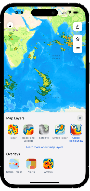
Map Layers in RainViewer: A Quick Overview
No matter if you are new to RainViewer or have been with us for a long time, here is a recap of all our weather map layers:
| Name | What It Shows | Data Source |
|---|---|---|
| Radar | Rain, snow | Radar |
| Radar and Satellite | Rain, snow, clouds | Radar, Satellite |
| Satellite | Clouds | Satellite |
| Single Radar | Precipitation from specific radar stations | Radar |
| Global Rain&Snow | Rain, snow | Satellite |
You can also watch a quick video about all layers in RainViewer:
Plan your outdoor adventures anywhere on Earth with RainViewer’s Global Rain & Snow map layer!


