
In May 2023, the World Meteorological Organization announced the high chances of El Niño’s return after the end of the three-year La Niña. Why do these two weather phenomena matter so much that they are announced in the news? Let’s find out in this article.
Several decades ago, the Spanish words El Niño and La Niña entered the world’s scientific literature, meaning a male and female infant, respectively. The Pacific Ocean near the equator got warmer, causing heavy rains and deaths of animals, floods and storms. South Americans called such a state El Niño. When the ocean cooled down, La Niña occurred. Since the mid-1900s, scientists have actively studied these climatic phenomena to get a better understanding of their impact on global weather patterns. So what are El Niño and La Niña?
El Niño is a phenomenon in which the surface water temperature of the tropical Pacific Ocean increases by about 41°F (5°C). During La Niña, the oceanic temperatures drop by approximately the same amount. Actually, both states are extreme stages of a single phenomenon.
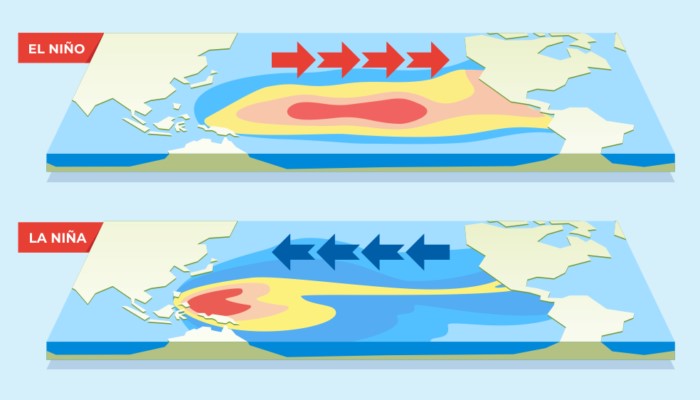 Image source: AHA Centre
In the 1930s, Sir Gilbert Walker and other climatologists discovered that El Niño happens at the same time as the Southern Oscillation. The Southern Oscillation is a shift in air pressure over the tropical Pacific Ocean. When the water near the coast gets warmer in the eastern tropical Pacific (El Niño), the air pressure above the ocean drops. Climatologists refer to this connection between El Niño and the Southern Oscillation as El Niño-Southern Oscillation (ENSO). Today, most scientists use El Niño and ENSO as synonyms. When there are no signs of El Niño or La Niña, climatologists speak of an ENSO-neutral state.
How Do El Niño and La Niña Impact Global Weather Patterns?
Both events change the weather, especially in regions near the tropical Pacific. In El Niño years, the Pacific coast in South and North America tends to get wetter, as more water evaporates from the warmer Pacific. In the La Niña years, the climate in the tropical Pacific Ocean gets drier.
In Southeast Asia and Australia, on the other hand, droughts are more common in El Niño years, while La Niña favors heavy rains and flooding. Examples are the heavy monsoon rains in Pakistan in the summer of 2022 or the repeated flooding in Australia in recent years.
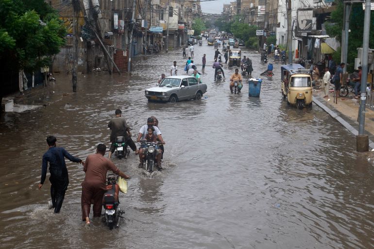 Image source: Aljazeera
, Farid Khan/AP
Image source: Aljazeera
, Farid Khan/AP
Through so-called remote effects, however, the ENSO system also has an impact on the weather in regions far from the equatorial Pacific. In the Horn of Africa, for example, droughts are more likely to occur in La Niña years, as in recent years.
Although the La Niña and El Niño phenomena are often spoken of, they are not clearly distinguishable events. Rather, the ENSO system is always in a state that is more La Niña-like or more El Niño-like. It’s possible to measure this state by indices that show how water, air, or pressure vary across the Pacific. If such an index exceeds a certain threshold, it is called a La Niña or an El Niño event, respectively.
The warm and cool phases of the constantly repeating climate pattern in the tropical Pacific occur irregularly every two to seven years. Each phase triggers changes in temperature, precipitation, and wind. For example, La Niña brings more Atlantic hurricanes when the hurricane season starts. At the same time, El Niño is more favorable for tropical cyclones in the Pacific region.
El Niño and La Niña Forecasting
Forecasting El Niño and La Niña events is a challenging task that requires monitoring and analyzing various oceanic and atmospheric variables. Climate scientists use a combination of observations, statistical models, and sophisticated computer simulations to make predictions. Here are some key techniques employed in the forecasting process:
- Sea surface temperature (SST) monitoring. Predicting and monitoring the temperature anomalies in the tropical Pacific Ocean is a crucial component of El Niño and La Niña forecasting. Satellite measurements, buoys, and other observational tools provide data on sea surface temperatures, helping scientists detect anomalies that may indicate the development of these events.
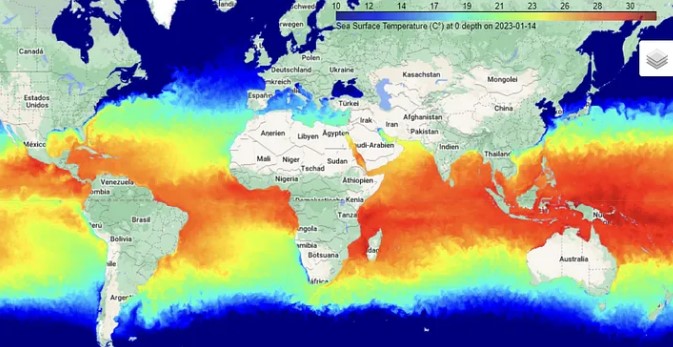 Image source: Bryan R. Vallejo, Toward Data Science
Atmospheric indices. Researchers use indices, such as the Southern Oscillation Index and the Equatorial Southern Oscillation Index, to evaluate the state of the atmosphere in response to ENSO. They derive these indices from measurements of atmospheric pressure differences and wind patterns.
Climate models. Sophisticated computer models known as coupled ocean-atmosphere models simulate the interactions between the ocean and the atmosphere. By incorporating historical data and current observations, scientists can run simulations to project future ENSO conditions. These models consider various factors, including ocean heat content, wind patterns, and the distribution of atmospheric moisture.
Conclusion
El Niño and La Niña are significant weather phenomena that have a global impact on weather patterns. These events result from the El Niño-Southern Oscillation (ENSO) cycle, with El Niño and La Niña representing extreme stages. The impacts of El Niño and La Niña are strongest in regions near the tropical Pacific. However, remote effects also influence weather patterns in distant regions. Here’s a short comparison of El Niño vs. La Niña:
| El Niño | La Niña | |
|---|---|---|
| Pacific surface temperatures | High | Low |
| Trade winds | Weak | Strong |
| Rainfall | Increased rainfall on the western coasts of the Americas | Increased rainfall in the western Pacific |
| Droughts | Increased droughts in the western Pacific | Increased droughts in the western coasts of the Americas |
| Tropical cyclones and hurricanes | More tropical cyclones in the central and eastern Pacific and fewer hurricanes over the Atlantic | Fewer tropical cyclones in the central and eastern Pacific and more hurricanes over the Atlantic |


