Know Before It Rains: Plan Your Day with Weather Radar
For many of us, checking the weather is a morning ritual. But there’s a difference between glancing at a general forecast and truly understanding what the sky has in store. RainViewer helps users move past vague forecasts to see real radar data showing current and upcoming weather.
In this guide, we’ll show you how to turn RainViewer weather radar into a personal planning tool. Whether you’re walking your dog, biking to work, or managing an event, this is your blueprint for using radar like a forecast-savvy pro.
1. Start with the Right Radar View
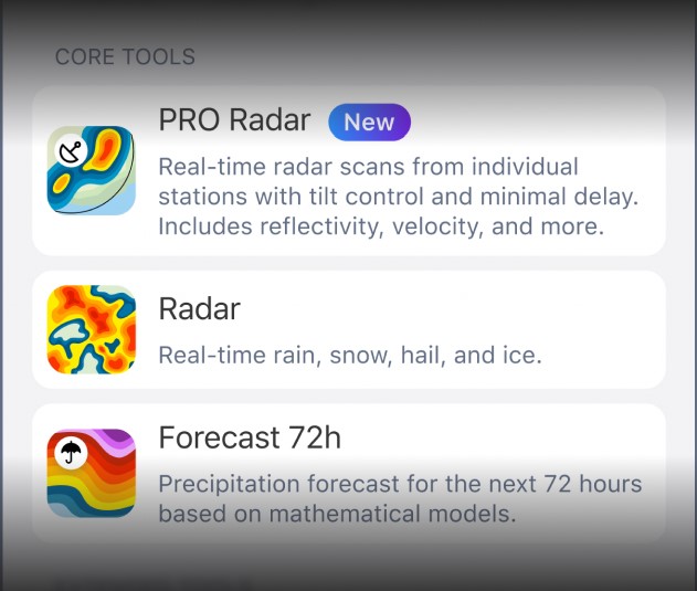
Before diving into rain predictions, make sure you’re viewing the most relevant data. RainViewer offers access to real-time radar data from over 100 sources and over 1,000 weather radar stations across the globe. You can check precipitation in two ways:
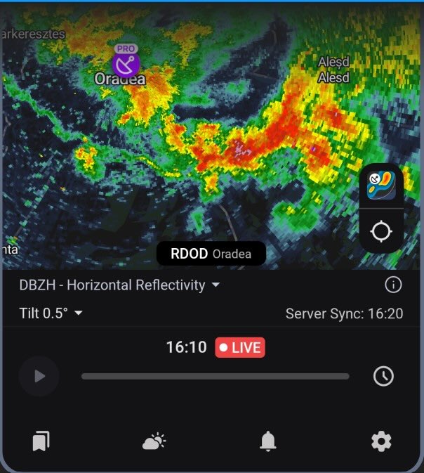
from a specific radar station (PRO Radar layer);
as a composite view from all radar stations available to us (Radar layer).
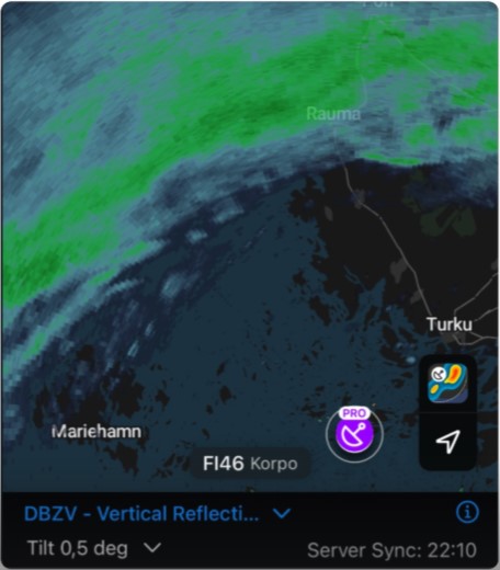
In the PRO Radar layer, you can choose the nearest radar station on the map. Please note that radar stations marked with PRO display extra advanced radar data like vertical reflectivity and radial velocity.
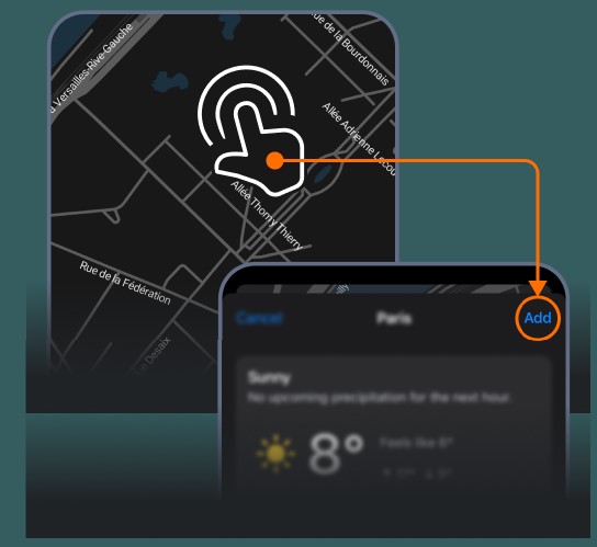
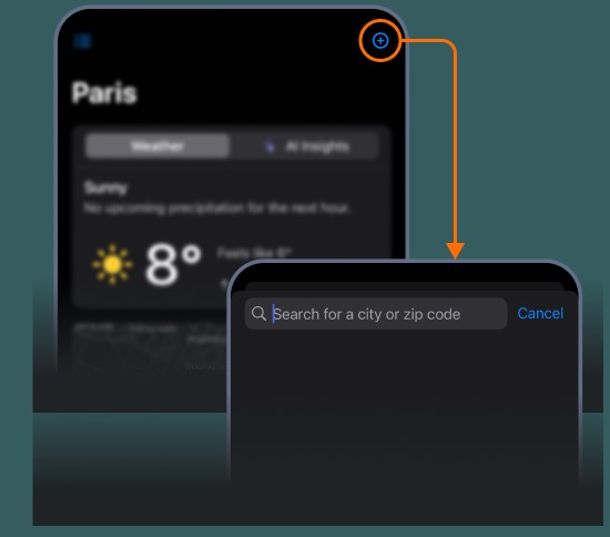
The Radar layer shows precipitation for your current location, but you can add more. Either long-tap a location on the map to save it or search for it manually from the Weather Summary screen.
Now, check that you’re using the standard horizontal reflectivity radar layer. This view shows precipitation intensity marked with colors. For most day-to-day planning, this is the key radar layer to watch.
2. Understand Radar Colors and What They Mean
Color is one of key elements in radar-based forecasting. Here’s a quick breakdown of what different shades typically mean:
- Light blue/green: Light rain or drizzle. Might not even need an umbrella.
- Yellow/orange: Moderate to heavy rain. You’ll want rain gear.
- Red/purple: Intense rainfall, possibly with thunderstorms. Time to reconsider any outdoor plans.
By learning to interpret these colors, you can make more informed decisions at a glance.
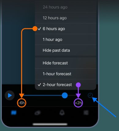
3. Use the Timeline to Track Movement
RainViewer’s animated timeline feature is more than a cool visual. It’s a tool for understanding storm movement. Use the timeline slider to replay data from the past or preview up to the next 2 hours of forecast.
This lets you:
- See direction: “Is that cluster of showers moving toward or away from me?”
- Estimate timing: “How fast is the rain approaching? Will it hit during my commute or pass before I step outside?”
- Spot development: “Are storms growing stronger or weakening?”
With just a few seconds of observation, you can determine whether to wait 30 minutes or carry on with your plans.
4. Set Smart Notifications
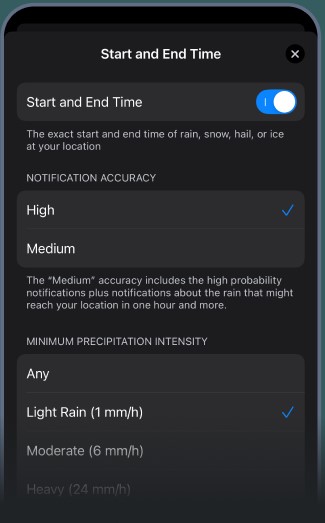
Don’t want to stare at the radar all day? You don’t have to. RainViewer lets you set custom rain alerts so you know when precipitation is approaching. You have the following options:
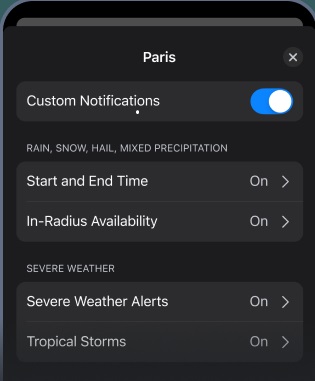
Start and End Time: Know exactly when rain, snow, or hail begins and ends - right at your location.
In-Radius Availability: Get alerts when rain, snow, or hail enters your chosen radius to stay ahead of nearby weather before it hits.
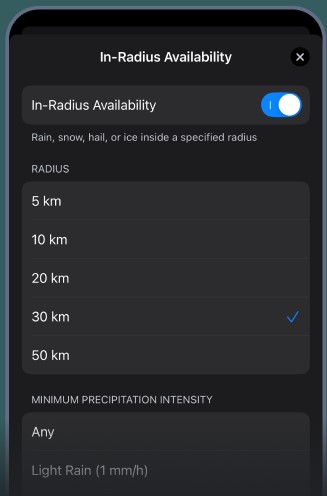
Intensity: Set a minimum precipitation intensity to avoid alerts for very light or brief showers.
Custom Notifications: Set up specific types of alerts for your family’s town, lake house, or travel route.
5. Combine Radar with Common-Sense Forecasting
Radar is powerful, but even the best data needs interpretation. Here are a few tips amateur experts rely on:
- Compare radar with hourly forecasts: If the radar looks clear but the hourly forecast shows 90% rain, there might be incoming cells outside your view.
- Watch for pop-up storms: On hot, humid days, isolated storms can form quickly. Keep radar open and refresh often.
- Know local weather quirks: Coastal breezes, mountains, and urban heat can all affect local patterns.
The more you use radar, the more you’ll notice patterns specific to your area.
6. Practice Makes Perfect
Forecasting with radar is part science, part skill. The best way to sharpen your instincts is to practice:
- Check radar before going outside.
- Make a mental prediction: Will it rain in the next 30 minutes?
- Recheck afterward and see how you did.
Over time, you’ll start picking up on the signs that precede a storm or the conditions that typically result in a near miss.
7. Your Day, Your Forecast
RainViewer transforms weather tracking from a passive check into an active strategy. With real-time data, short-term forecasts, and a toolkit designed for weather enthusiasts, you can take control of your day, one radar frame at a time.
So next time you see clouds on the horizon, don’t guess. Instead of asking, “Will it rain today?” ask a better question: “When will it rain, and how much?” That’s what RainViewer weather radar can help answer.


