
Forecasting the weather isn’t just a science - it’s a skill. And like any skill, it sharpens with time, curiosity, and the occasional wrong call. From misread radar echoes to overconfidence in a single model run, even seasoned enthusiasts hit bumps along the forecasting road.
At RainViewer, we believe every misstep is a chance to grow. So we’ve gathered five of the most common pitfalls that trip up amateur meteorologists and radar geeks alike.
1. Radar Confusion: When Echoes Lie
Radar is powerful but it doesn’t always tell a straightforward story. One of the most frequent mistakes is assuming that all reflectivity equals precipitation.
Ground clutter, for example, creates false returns, especially near radar installations. These echoes don’t move, don’t grow, and don’t mean rain. Flocks of birds, swarms of insects, even distant smoke can produce misleading signals too.
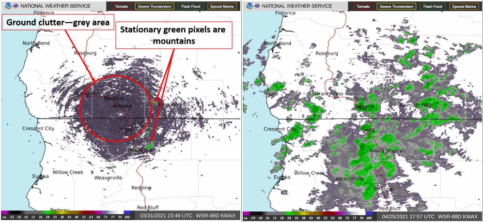
Source: National Weather Service
Then there’s virga : precipitation that evaporates before reaching the ground. It shows up as strong returns but stays dry at the surface.
- Check for consistency across frames. If a blotch doesn’t move like a storm, it probably isn’t one.
- Use METAR data or nearby stations in RainViewer to cross-check real-world conditions.
- Look at structure and motion, not just color intensity.
Extra Tip: Velocity layers help confirm motion and intensity. Use them to separate signals from noise.
2. Trusting One Model Too Much
Forecast models are incredible tools. But they’re still just models - simplified versions of the real world, each with its quirks.
The GFS might spot trends early but miss fine details. ECMWF is often a favorite for accuracy, but it, too, has blind spots. High-res models like HRRR offer granularity but can also overdo it.
- Compare multiple model runs in RainViewer to track trends.
- Use ensemble data when available - it shows spread and uncertainty.
- Ask yourself: What do multiple models agree on? Where do they diverge?
3. Forgetting Local Factors
Models paint with a broad brush but weather happens in the fine strokes. Terrain, water bodies, and urban development can create sharp microclimates that most models can’t fully resolve.
A forecast may show clear skies but fog might cling to coastal zones. Or convection could flare up on the downwind side of a mountain ridge, while neighboring regions stay calm.
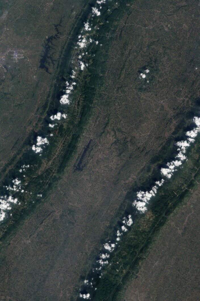
Source: NASA Earth Observatory
- Add local personal weather stations (PWS) to your location list in RainViewer for real-time hyper-local insight.
- Use the 48-hour radar archive to spot recurring local patterns.
- Consider urban heat islands, tree canopy cover, and elevation changes in your area.
4. Chasing Every Model Run
It’s tempting to refresh for every new update, especially before a storm. But short-term fluctuations are normal. Reacting to each shift can create a forecast “whiplash” and cloud your judgment.
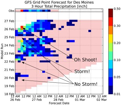
Source: Iowa State University
Instead of fixating on a single run, track how the forecast evolves over time.
- Use RainViewer’s model playback to see the last several runs in motion.
- Look for run-to-run consistency - that’s where confidence builds.
- Watch for trend reversals or convergence between models.
Pro Tip: Be patient. Trust the trend, not the latest headline.
5. Misjudging Storm Severity
Just because something looks severe on radar doesn’t mean it is - and vice versa.
A high dBZ reading might mean hail or snow aloft, not heavy rain at the surface. Conversely, subtle radar signatures like bow echoes or low-level rotation might hint at damaging winds or tornadoes that aren’t visually obvious.
A common mistake is focusing only on high reflectivity (bright reds/pinks on radar) and assuming it always means extreme weather. In reality, context matters - for example, a hook echo on a supercell (a hook-shaped appendage) often indicates a possible tornado.
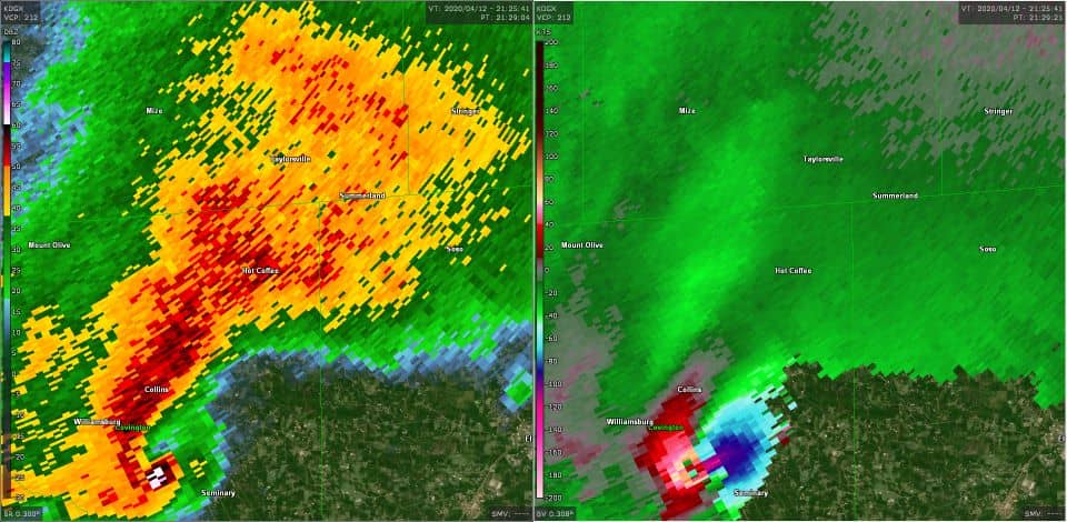
Source: National Weather Service
- Learn key radar patterns: hook echoes, bowing segments, debris signatures.
- Cross-check with NWS alerts and spotter data through RainViewer.
- Zoom in and analyze storm structure with high-resolution radar overlays.
Key idea: Don’t just chase color. Read the story radar is telling.
Final Forecast: Growth Comes From Curiosity
The best weather radar interpreters aren’t the ones who never get it wrong. They’re the ones who stay curious, question their assumptions, and keep learning with every frame and every forecast.
RainViewer was built for this mindset. We provide raw radar data, smooth animations, customizable alerts, and access to multiple forecast models - because we believe that with the right tools, anyone can level up their weather intuition.


