
Hurricane Otis stands as a historic weather event, being the strongest tropical storm ever documented in the Western Hemisphere. It exceeded the previous record set by Hurricane Patricia in 2015.
On October 25, after a landfall on the Pacific coast of Mexico near Acapulco, Otis unleashed wind gusts reaching 165 mph (270 km/h), leading to extensive flooding and landslides. As of October 29, 2023, the death toll included 48 confirmed fatalities. The devastating impact left Acapulco, a city of 900,000 residents, without electricity and communication.
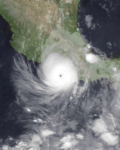 Image source: Wikipedia
What makes this event stand out is not just its sheer force but the alarming forecasting failures that surrounded it. Hurricane Otis rapidly intensified from a Category 1 hurricane to a Category 5 monster within 24 hours. It caught meteorologists off guard and highlighted the critical importance of accurate hurricane strength prediction.
Hurricane Otis Path and Timeline
The Otis hurricane path began on October 15, 2023, with the National Hurricane Center’s initial report of a low-pressure area south of Guatemala and El Salvador. On October 22, it had evolved into a tropical storm, steadily moving northward.
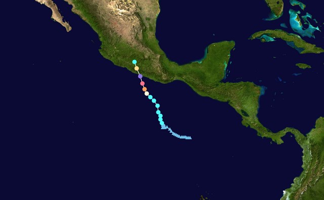 Image source: Wikipedia
Having become more intensive on October 24, the Acapulco hurricane was fueled by high ocean surface temperatures of about 86-88°F (30-31°C). These temperatures were abnormally high, exceeding the 1991-2020 average by 1.8°F (1°C).
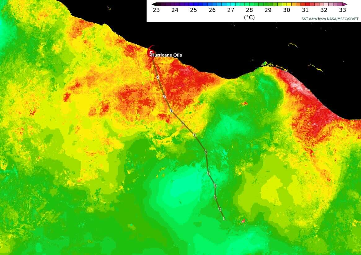 Image source: Brian McNoldy on X (ex-Twitter)
On October 25, the hurricane had surged to Category 3, and on the same day, it reached Category 5. During the day, wind speeds escalated from 53 mph (85 km/h) to 165 mph (270 km/h), and then Otis made landfall on the Mexican coast near Acapulco. Notably, the hurricane remained rather compact, with its strongest winds confined to a radius of 68 miles (110 km) around the center. Upon landfall, the Mexico hurricane quickly lost its intensity and dissipated on the same day. Here’s what the Otis landfall looked like on the RainViewer animated map.
In terms of wind speed, Otis belongs to the strongest landfalling hurricanes on the Pacific coast:
| Name | Year | Speed |
|---|---|---|
| Otis | 2023 | 165 mph (270 km/h) |
| Patricia | 2015 | 150 mph (240 km/h) |
| Madeleine | 1976 | 145 mph (230 km/h) |
| Iniki | 1992 | |
| Twelve | 1957 | 140 mph (220 km/h) |
| “Mexico” | 1959 | |
| Kenna | 2002 | |
| Lidia | 2023 |
Hurricane Otis Forecasting Mistakes
Hurricane Otis’s rapid intensification was one of the most significant errors in the history of weather forecasting . Meteorologists were struggling to predict the storm’s strength due to a lack of data in the East Pacific. Initial forecasts predicted a weak tropical storm, but Otis intensified into a Category 5 hurricane just hours before landfall.
One reason for the hurricane forecasting error was the limited availability of data. The East Pacific has fewer weather stations and buoys than other parts of the world, making hurricane intensity prediction quite difficult. Forecasters also struggled to predict Otis’s vertical alignment, which plays a key role in tropical storm intensity.
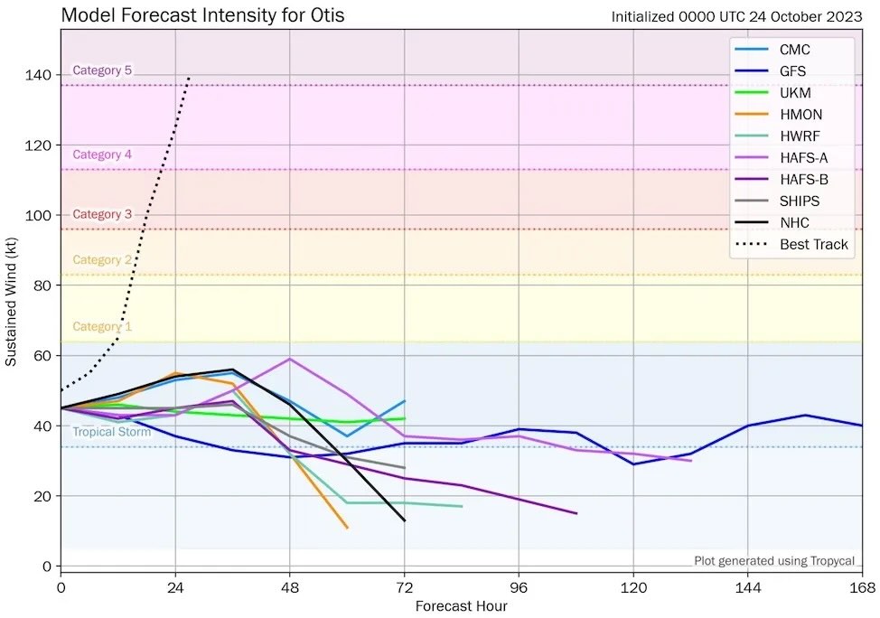 Image source: Tomer Burg on X (ex-Twitter)
Another reason for the forecasting error was the lightning-fast rate of intensification. Otis intensified from a Category 1 to a Category 5 hurricane in less than 24 hours. Such a rapid intensification over a relatively small area is quite difficult to predict. The National Hurricane Center upgraded Otis to Category 4 about six and a half hours before landfall and explicitly predicted its ascent to Category 5.
However, by the time the storm made landfall on October 25, it had already intensified into a Category 5 hurricane. The inaccurate prediction of the Otis hurricane (Acapulco) serves as a reminder that tropical storms can unexpectedly change their category, even with the latest forecasting technology.
Hurricane Otis Mexico: Consequences
The consequences of Hurricane Otis were severe, prompting the Mexican government to issue a warning 21 hours prior to landfall. The city’s port and airport were closed, and schools suspended operations. The natural disaster caused extensive damage in the state of Guerrero, including:
- 1 power plant,
- 26 substations,
- 37 power lines,
- 10,000 lampposts.
Approximately 500,000 people were left without electricity, and over 220,000 houses were damaged, including 600 hotels and condos. The hurricane’s ferocity even shattered windows and walls on high-rise buildings.
 Image source: Alejandro Cegarra/Bloomberg/Getty Images
As of October 29, the weather event resulted in 48 confirmed fatalities, with an additional 36 individuals reported as missing. The overall financial losses were estimated to be between $10 and 15 billion, surpassing the total damage incurred by all previous hurricanes in Mexico.
Conclusion
Hurricane Otis (Acapulco, Mexico) underlines the need for improved forecasting capabilities, especially in regions with limited data. The consequences of forecasting errors, including loss of life and extensive damage, emphasize the urgency of investing in meteorological infrastructure and technology.


