
Rain radar is a valuable tool for meteorologists. It helps them track rainfall in real time and predict severe weather like heavy rain and floods. Understanding how rain radar detects heavy rainfall and assesses flood risks is key to appreciating modern weather prediction technology. This article will explore how rain radar systems spot heavy rainfall and evaluate the potential for flash floods.
Detecting Radar Rainfall and Flash Floods
With tools like RainViewer, you can track extreme rainfall in real time. Rain radar detects severe weather using key indicators like:
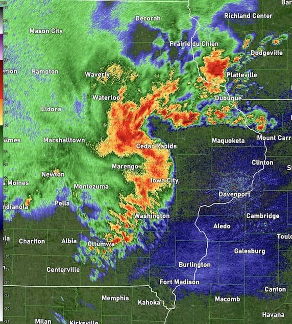
- Reflectivity values. The intensity of returned signals is measured in dBZ. Higher dBZ values indicate heavier precipitation. For example, values above 50 dBZ often signify intense rainfall or hail.
 Source: NOAA
 - Radar rainfall estimates. By correlating reflectivity with known rainfall rates, meteorologists can estimate how much rain occurs in a given area over time.
- Storm cell tracking. Advanced weather radars track storm movement and structure to identify areas with prolonged or intense rainfall, which increases the risk of flooding.
Want to track storm development like a pro? Use RainViewer’s radar loops to watch storm cells evolve in real time. Look for high reflectivity values (50 dBZ+) and training storm patterns-both early warning signs of potential flash flooding.
Predicting Flood Event Risks by Using Rainfall Data
While rain radar is primarily designed to detect precipitation, it also plays a critical role in flood risk management. Heavy rainfall alone does not always lead to flooding. However, when combined with factors like soil saturation, terrain, and drainage systems, the risk increases significantly.
Key radar indicators for flash flood forecasting are as follows:
- Persistent heavy rainfall. If a region experiences continuous high reflectivity values over an extended period, it suggests a high likelihood of flooding.
- Training storms. Training refers to repeated movement of storm cells over the same area. In this case, excessive rain accumulation can overwhelm natural and artificial drainage systems, leading to flash floods.
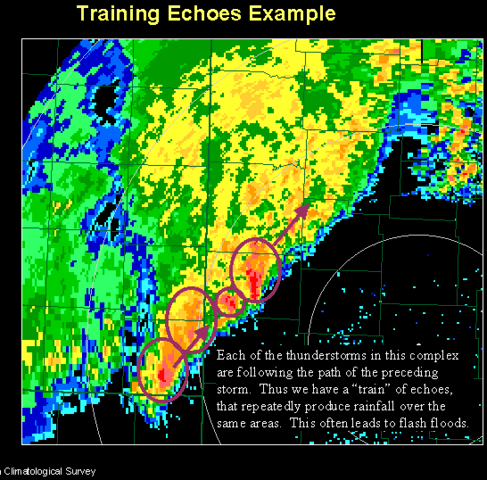 Source: NOAA, Public domain, via Wikimedia Commons
 - Storm motion and speed. Slow-moving storms or stationary fronts increase the potential for localized flooding.
- Rainfall accumulation estimates. Advanced radar models can estimate total precipitation over a given period, helping meteorologists assess whether an area is approaching or exceeding flood thresholds.
The Role of Dual-Polarization Radar in Flood Risk Assessment
Unlike traditional weather radars, dual-polarization radar offers better classification of precipitation and improved estimates of rainfall. This technology can:
- Differentiate between rain, hail, and snow, providing more accurate precipitation intensity readings.
- Reduce false alarms by filtering out non-weather objects like birds or debris.
- Improve quantitative precipitation estimates (QPE), which help predict water accumulation and potential flood risks more precisely.
Real-Life Examples of Radar in Flash Flood Forecasting
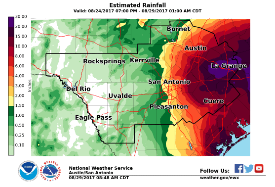
One notable example of rain radar aiding in flood risk assessment was Hurricane Harvey (2017). Weather radar provided critical real-time data showing the immense rainfall rates over southeastern Texas. Some areas received over 40 inches (1000 mm) of rain. Radar analysis helped emergency responders anticipate flooding impacts and issue timely flash flood warnings.
Another example is the use of radar in monitoring monsoon rains in South Asia. In countries like India and Bangladesh, radar technology helps predict heavy rainfall events that can lead to devastating floods, allowing for early evacuation and preparedness.
Limitations of Rain Radar in Flood Prediction
While radar technology is highly effective, it has limitations:
- Ground clutter and obstacles. Mountains, tall buildings, and other structures can interfere with radar signals, leading to inaccurate readings.
- Beam overshooting. At greater distances, radar beams may overshoot lower portions of the atmosphere, missing important low-level precipitation details.
- Dependence on algorithms. Rainfall estimation models rely on assumptions that may not always be precise, especially in complex weather systems.
To mitigate these limitations, meteorologists integrate radar data with satellite observations, rain gauge networks, and hydrological models for more comprehensive flood risk assessments.
How Flood Forecasting Works in the Future
With advancements in radar technology, weather prediction is becoming more accurate and timely. Future developments may include:
- Phased-array radar. This next-generation radar can scan the atmosphere much faster than traditional radar, improving early detection of severe storms and flood risks.
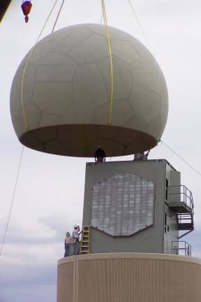 Source: Dr. Sebastian Torres (National Severe Storms Laboratory of NOAA), Public domain, via Wikimedia Commons
 - Machine learning and AI integration. Artificial intelligence helps enhance radar interpretation and predict flood risks with greater precision.
- Improved global radar networks. Expanding radar coverage, especially in developing regions, will provide better data for flood prediction worldwide.
Conclusion
Rain radar is an essential tool for detecting heavy rainfall and predicting flood risks. By analyzing radar reflectivity, storm motion, and rainfall accumulation, meteorologists can provide precise forecasts and quickly issue flash flood warnings.
While challenges remain, ongoing advancements in radar technology continue to improve our ability to monitor and respond to extreme weather events. Want to stay ahead of the next heavy rain event? Use RainViewer to track rainfall intensity, monitor storm movement, and receive real-time flood alerts.


