Hurricanes are among the most destructive and unpredictable forces of nature, causing widespread devastation when they make landfall. Weather radar is one of the most valuable tools in hurricane tracking. In this blog post, we’ll explore how radar technology helps track hurricanes, and why it’s an essential part of weather forecasting and disaster management.
The Role of Weather Radar in Hurricane Tracking
In the context of hurricanes, radar is used to monitor precipitation, wind patterns, and the structure of the storm. This allows meteorologists to track a hurricane’s movements, its intensity, and how it’s changing in real time.
Monitoring the Storm’s Position and Movement
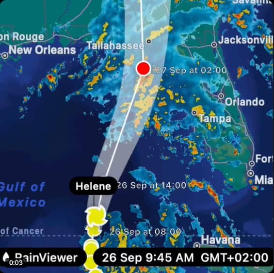
Hurricanes are massive storms that can span hundreds of miles, and tracking their movement is critical for issuing accurate warnings and forecasts. With real-time weather radar tools like RainViewer, you can track a hurricane’s exact position, movement, and intensity. Watch live storm updates and stay ahead of dangerous weather conditions.
Analyzing the Storm’s Structure
Radar helps weather experts visualize the storm structure, including the eye, eye wall, and surrounding rain bands. By observing the rotation and organization of these elements, it’s possible to assess the storm’s strength and estimate its potential impact.
Here’s an example of Hurricane Katrina radar reflectivity image. Brighter colors (yellow, orange, red) show intense rainfall in the eyewall surrounding the clear eye over southeast Louisiana.
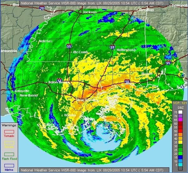
Source: NOAA National Weather Service (radar image via NOAA Flickr)
Identifying and Tracking Rainfall and Wind Speeds
Weather radar systems can identify areas of heavy rainfall within the storm, which is crucial for predicting flooding risks. By measuring the strength of rainfall, meteorologists can issue flash flood warnings in areas that might be at risk.
Additionally, radar can detect wind speeds within the hurricane, especially when used in conjunction with Doppler radar technology. Doppler radar measures the velocity of rain droplets, allowing meteorologists to estimate the speed and direction of winds within the storm. This information helps predict the hurricane’s potential for intensification or weakening.
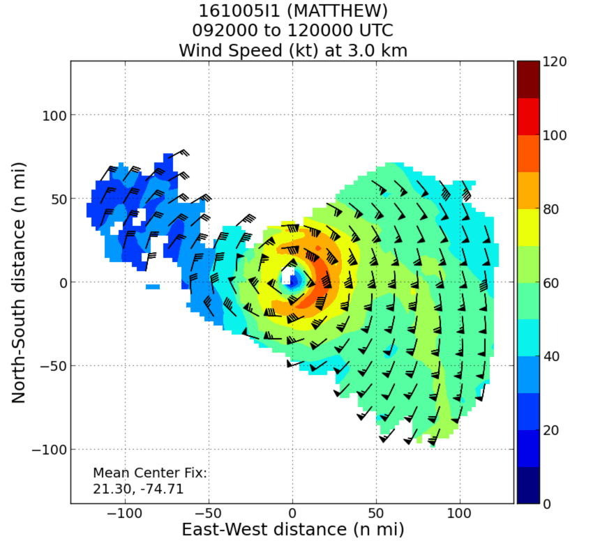
Source: NOAA
Tracking Changes in the Storm’s Path and Intensity
Hurricanes can change course unexpectedly or intensify rapidly as they approach land, and it is critical to have a reliable way to track these changes. Using RainViewer’s live radar , you can track hurricane path shifts in real time. Sudden changes in storm intensity or movement can indicate rapid strengthening.
Providing Real-Time Data to Emergency Responders
In addition to meteorologists, emergency responders rely on real-time radar data to prepare for a hurricane’s landfall. The information gathered from weather radar allows local governments to plan evacuations, allocate resources, and prepare shelters in areas that are expected to be hit hardest. Radar data is also vital for guiding search and rescue operations once the storm has passed.
The Benefits of Weather Radar in Hurricane Forecasting
Here’s how hurricane forecasting can benefit from the use of weather radar:
Improved Accuracy in Predicting Landfall
The precision of radar data allows for more accurate predictions of a hurricane’s landfall. By continuously monitoring the storm’s position, intensity, and movement, meteorologists can issue more reliable forecasts.
Enhanced Warning Systems
With radar technology, meteorologists can provide more timely and specific warnings. For example, they can issue warnings for areas that are most likely to experience heavy rainfall, severe winds, or storm surges. This allows residents to take appropriate precautions, whether evacuating, securing their property, or stocking up on supplies.
Faster Response Time
The real-time radar data helps emergency response teams react more quickly to changing conditions. This can save lives and reduce the overall impact of the storm by ensuring that resources are directed to the right places at the right time.
Better Decision-Making for Communities
When a hurricane approaches, local governments rely on radar data to make critical decisions about evacuations, school closures, and public safety measures. The more detailed and timely the radar data, the better equipped they are to protect the public.
Conclusion
Weather radar has become an indispensable tool in the monitoring and tracking of hurricanes. Stay ahead of the next hurricane with RainViewer’s real-time storm tracking. Monitor live radar updates, predict landfall, and get the latest alerts - because staying informed is the first step to staying safe.


